amateur radio
APRS
automatic packet reporting system
ham radio
radio amatur
9M2PJU APRS map, 9M2PJU online aprs map, aprs malaysia map, aprs online map, aprs tracking website, aprs.fi alternative, automatic packet reporting system map, ham radio aprs online map, malaysia aprs map, map for aprs, openstreetmap aprs, opentopomap aprs, peta aprs online, web based aprs map
9M2PJU
0 Comments
9M2PJU APRS Map: A Comprehensive Guide for Amateur Radio Operators
The world of amateur radio is vast and filled with numerous opportunities for communication, exploration, and learning. One of the most exciting aspects of this hobby is the Automatic Packet Reporting System (APRS), a digital communication protocol that has become a cornerstone for many operators. APRS enables the transmission of real-time data such as position, weather reports, and short messages, transforming the way we interact with the world through radio frequencies. For those deeply embedded in this system, having a reliable and user-friendly platform to access and interact with APRS data is crucial. This is where the 9M2PJU APRS Map hosted at http://maps.hamradio.my/ comes into play.
What is APRS?
Before diving into the details of the 9M2PJU APRS Map, let’s explore what APRS is and why it’s such an essential tool for amateur radio enthusiasts.
APRS, or Automatic Packet Reporting System, is a real-time digital communication system that operates over amateur radio frequencies. Developed by Bob Bruninga, WB4APR, in the late 1980s, APRS was designed to track the positions of moving objects like vehicles or weather balloons, share messages, and transmit other real-time data across a network of stations.
At its core, APRS leverages the Global Positioning System (GPS) to determine the exact location of an object, which is then transmitted over radio frequencies. This data can include a wide range of information:
- Position reports: These are the most common type of APRS data, used to track the location of stations, vehicles, or other objects.
- Weather data: Many APRS stations are equipped with weather sensors, transmitting real-time information such as temperature, humidity, wind speed, and direction.
- Short messages: APRS also allows for the transmission of brief text messages between stations, making it a valuable tool for communication during events or emergencies.
- Telemetries and Alerts: APRS can be used to transmit telemetry data or alerts from remote stations or objects, such as a weather balloon or a buoy in the ocean.
What makes APRS particularly powerful is its ability to relay this data across a global network. Stations equipped with APRS capabilities can transmit their data over the air, where it can be received by other stations and even uploaded to the internet through APRS-IS (APRS Internet Service). This makes it possible for operators to monitor APRS data from anywhere in the world, provided they have internet access.
Introducing the 9M2PJU APRS Map
Now that we have a solid understanding of APRS, let’s turn our attention to the 9M2PJU APRS Map. This web-based platform, accessible at http://maps.hamradio.my/, is designed to provide a user-friendly interface for tracking and interacting with APRS data. Whether you’re a seasoned operator or a newcomer to the world of APRS, the 9M2PJU APRS Map offers a range of features that make it an indispensable tool.
Key Features of the 9M2PJU APRS Map
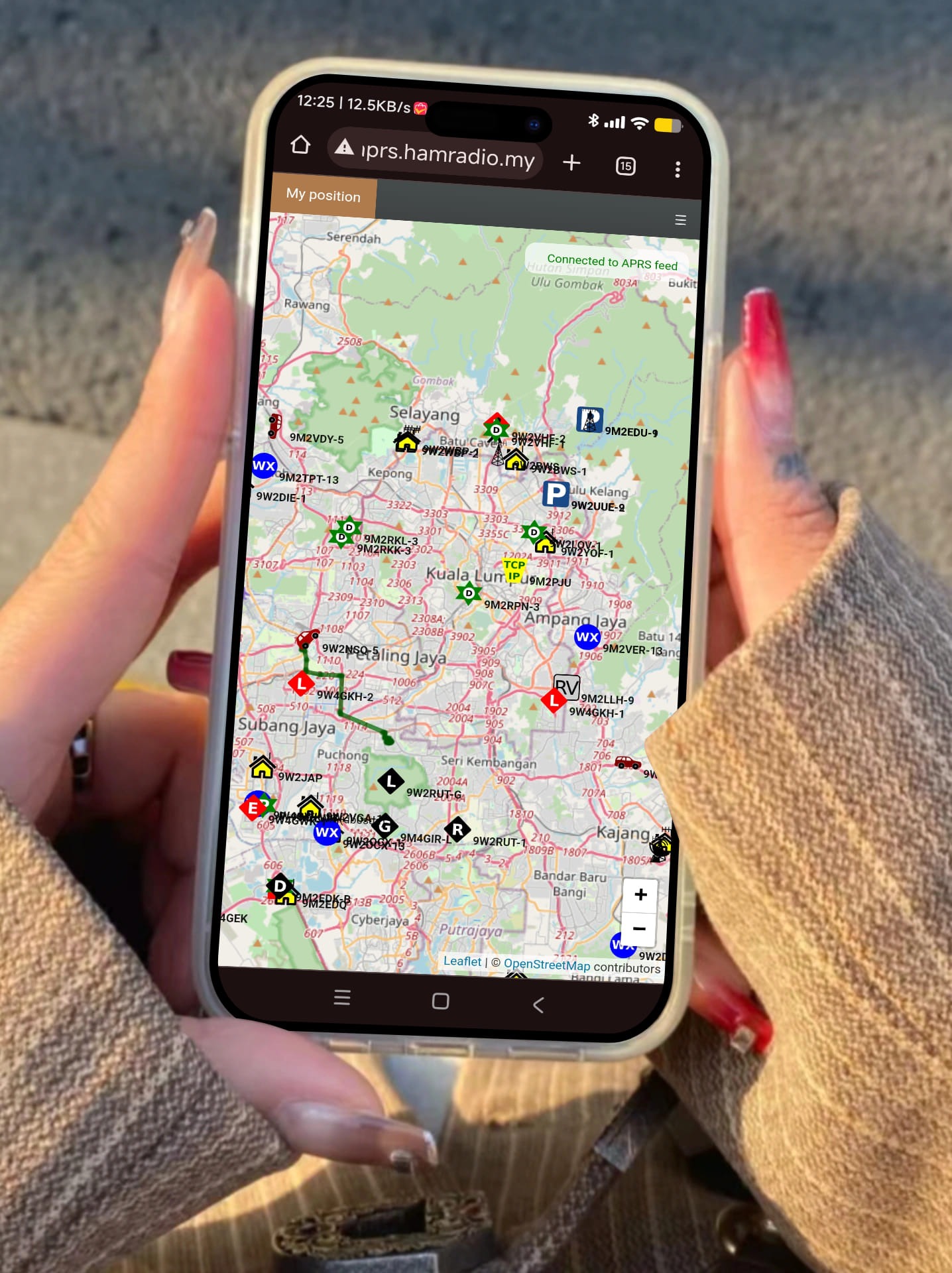
- Web-Based Interface: One of the most significant advantages of the 9M2PJU APRS Map is its web-based interface. Unlike many other APRS tools that require specific software installations or technical expertise, this platform can be accessed directly from any modern web browser. This means you can use it on your desktop, laptop, tablet, or smartphone, making it incredibly versatile and convenient.
- Real-Time Tracking: The 9M2PJU APRS Map provides real-time tracking of APRS-enabled stations, allowing you to monitor the positions of other operators, vehicles, or even weather balloons as they move. This is particularly useful for tracking events, coordinating activities, or simply keeping an eye on the movement of objects within your area of interest.
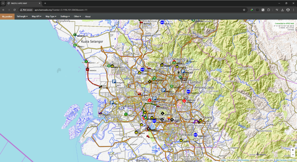
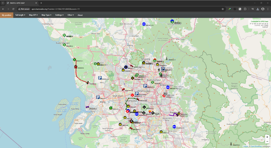
- Integration with OpenStreetMap and OpenTopoMap: To provide the best possible mapping experience, the 9M2PJU APRS Map integrates with both OpenStreetMap and OpenTopoMap. OpenStreetMap (OSM) is a collaborative project that provides free, editable maps of the world. It offers detailed and up-to-date geographical information that is invaluable for APRS users. OpenTopoMap, on the other hand, is designed to provide topographic maps, which include elevation data and contour lines, making it ideal for outdoor activities and terrain analysis. By combining these two mapping systems, the 9M2PJU APRS Map offers a rich and detailed view of the world, allowing you to see not just the position of stations but also the geographical context in which they operate.
- Local and Global Focus: While the 9M2PJU APRS Map allows you to view APRS data from around the world, it places a special emphasis on the Malaysian amateur radio community. As a Malaysian-based platform operated by the callsign 9M2PJU, it offers a unique focus on local stations and activities. This makes it an invaluable resource for operators in Malaysia who want to stay connected with the broader community, track local events, or participate in national exercises.
- Seamless APRS Integration: The 9M2PJU APRS Map is designed to seamlessly integrate with your existing APRS setup. Whether you’re using a handheld transceiver with APRS capabilities, a mobile rig, or a dedicated APRS device, you can easily see your data reflected on the map. This integration is effortless, requiring no special configurations—just set up your APRS device, and your data will appear on the map as soon as it’s transmitted.
- Connecting to the 9M2PJU APRS Internet Server: For those who want to connect their APRS client directly to the 9M2PJU APRS Internet Server, it’s as simple as adding
aprs.hamradio.myto your APRS client settings. This connection allows your APRS-enabled devices to transmit data directly to the internet, making it visible on the 9M2PJU APRS Map and accessible to other operators around the world. - Operated by an Experienced Amateur Radio Operator: The 9M2PJU APRS Map is not just another automated service—it’s operated by an experienced amateur radio operator with the callsign 9M2PJU. This means that the platform is managed by someone who understands the needs and challenges of APRS users. The site is regularly updated and maintained, ensuring that it remains a reliable resource for the amateur radio community.
The Importance of APRS in Amateur Radio
To fully appreciate the value of the 9M2PJU APRS Map, it’s essential to understand the broader role that APRS plays in the world of amateur radio. APRS is not just a tool for tracking positions—it’s a versatile communication system that serves a wide range of purposes.
1. Emergency Communication:
In times of emergency, APRS can be a critical tool for communication. When traditional communication systems fail, amateur radio operators often step in to provide vital links between emergency responders, disaster relief organizations, and affected communities. APRS can be used to track the positions of emergency vehicles, relay messages, and provide real-time updates on weather conditions or other critical data.
The 9M2PJU APRS Map can play a vital role in these scenarios by providing a centralized platform for tracking and coordinating the activities of amateur radio operators during emergencies. Its real-time tracking and seamless integration with APRS devices make it an invaluable tool for emergency communication.
2. Event Coordination:
Whether it’s a large-scale public event, a community gathering, or a radio contest, APRS is often used to coordinate the activities of participants. By tracking the positions of key individuals or assets, organizers can ensure that everyone is in the right place at the right time, and can respond quickly to any issues that arise.
The 9M2PJU APRS Map provides an ideal platform for event coordination, offering real-time visibility of all participants and assets. Its web-based interface means that it can be accessed by multiple users simultaneously, making it easy for teams to collaborate and stay informed.
3. Exploration and Adventure:
For those who enjoy outdoor activities such as hiking, camping, or off-roading, APRS offers a way to stay connected and share your adventures with others. By transmitting your position in real-time, you can keep your friends and family updated on your progress, or connect with other operators who are nearby.
The integration of OpenStreetMap and OpenTopoMap on the 9M2PJU APRS Map makes it an excellent tool for outdoor exploration. You can use the detailed topographic maps to plan your route, monitor your position, and even discover new trails or points of interest.
4. Educational Purposes:
APRS is also a valuable educational tool, both for individual learning and group instruction. It offers a practical way to learn about radio communication, GPS technology, and data transmission, all while participating in a global network of operators.
Teachers and instructors can use the 9M2PJU APRS Map as a teaching aid, showing students how APRS works in real-time. By tracking stations on the map, students can see how data is transmitted, received, and shared across the network, providing a hands-on learning experience.
Getting Started with the 9M2PJU APRS Map
If you’re ready to start using the 9M2PJU APRS Map, getting started is easy. Here are the basic steps:
- Access the Map: Simply open your web browser and navigate to http://maps.hamradio.my/. The map will load automatically, showing you the latest APRS data from around the world.
- Zoom and Pan: Use the zoom and pan controls to explore different areas of the map. You can zoom in to see more detail, or zoom out to get a broader view of the region. The map will automatically update as you move around, displaying the latest data for the area you’re viewing.
- Switch Between Map Types: The 9M2PJU APRS Map allows you to switch between OpenStreetMap and OpenTopoMap views. Use the map controls to select the type of map that best suits your needs. For urban areas or general navigation, OpenStreetMap is usually the best choice. For outdoor activities or terrain analysis, OpenTopoMap provides valuable topographic information.
- Track Stations: As you explore the map, you’ll see various icons representing APRS-enabled stations. Click on any icon to view detailed information about that station, including its position, speed, altitude, and any messages or data it has transmitted.
- Connect Your APRS Client: If you want to transmit your data directly to the 9M2PJU APRS Map, you’ll need to connect your APRS client to the 9M2PJU APRS Internet Server. To do this, simply add
aprs.hamradio.myto your APRS client settings. Once connected, your data will be transmitted to the server and displayed on the map in real-time. - Stay Updated: The 9M2PJU APRS Map is regularly updated with the latest APRS data, so be sure to check back often to see what’s new. You can also follow 9M2PJU on social media or subscribe to updates to stay informed about any new features or changes to the platform.
Conclusion
The 9M2PJU APRS Map is more than just a tool—it’s a gateway to the exciting world of APRS. By providing a user-friendly, web-based interface with integration to OpenStreetMap and OpenTopoMap, this platform makes it easier than ever for amateur radio operators to track, communicate, and explore using APRS.
Whether you’re coordinating an event, participating in emergency communications, or simply enjoying a hike in the mountains, the 9M2PJU APRS Map is an invaluable resource. And with the ability to connect your APRS client directly to the 9M2PJU APRS Internet Server, you can be sure that your data will be seen by others around the world.
So why wait? Visit http://maps.hamradio.my/ today and start exploring the world of APRS like never before. With the 9M2PJU APRS Map, the world is at your fingertips!


Post Comment