amateur radio
android tactical assault kit
ATAK
emergency communication
first responder
ham radio
mapping
situational awareness
AmateurRadio, APRS, ATAK, atakciv, EmComm, emergencycommunications, FieldDay, hamradio, hamradiodigital, lora, meshtastic, offlinegps, POTA, radiocomms, RadioTech, SAR, searchandrescue, situationalawareness, sota, tacticalmapping
9M2PJU
0 Comments
Exploring ATAK: Tactical Mapping and Communication for Amateur Radio Operators
In the evolving world of amateur radio, where situational awareness and field coordination are crucial—especially during activations, events, or emergencies—tools like ATAK (Android Team Awareness Kit) are gaining attention for their powerful features originally designed for military operations.
But what exactly is ATAK? And how can it benefit the amateur radio community?
What Is ATAK?
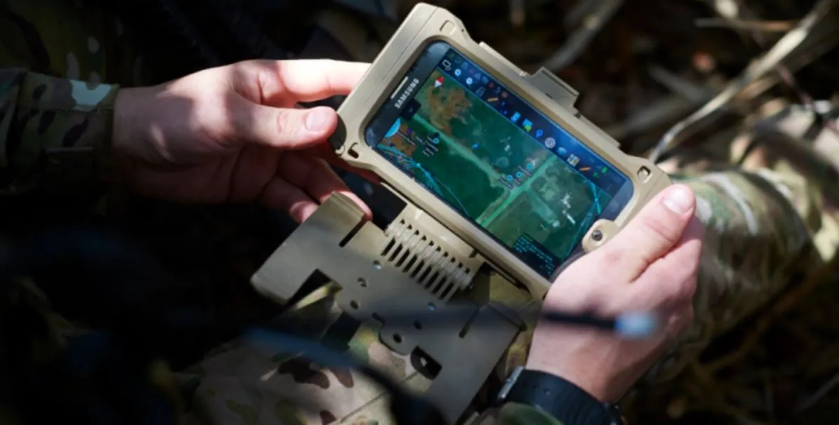
ATAK is a geospatial mapping and situational awareness tool originally developed by the Air Force Research Laboratory (AFRL) . It runs on Android devices and provides real-time team tracking, communication, mapping, and coordination capabilities.
ATAK was initially built for military special operations forces, and later adapted for use by law enforcement, search-and-rescue teams, firefighters, and now even civilians through a version called ATAK-CIV.
At its core, ATAK gives users a powerful map-based interface to:
- See the location of other users in real time (Blue Force Tracking)
- Share points, routes, and geofences
- Chat over various networks
- Use offline maps (MBTiles, GeoTIFF, etc.)
- Connect to radios, drones, sensors, and more
Military Origins and Field-Proven Capabilities
ATAK was born out of the need for situational dominance in high-risk tactical environments. Since its inception, it has seen extensive use in:
- Special Forces operations
- Coordinated drone strikes and ISR (Intelligence, Surveillance, Reconnaissance)
- Disaster relief missions and humanitarian assistance
The military-grade versions of ATAK allow seamless communication between air and ground units, display live video feeds from UAVs, and integrate with secure tactical radios like Harris and Thales. In these missions, ATAK was crucial in reducing friendly fire, increasing operational efficiency, and enhancing coordination across distributed teams.
How Amateur Radio Can Leverage ATAK
The civilian version of ATAK (ATAK-CIV) is publicly available and, while it doesn’t include all the secure military features, it retains the robust mapping and coordination tools—making it a great fit for amateur radio use, especially for:
1. Emergency Communications (EmComm)
During disasters like floods, forest fires, or earthquakes, hams often assist in relaying messages, tracking resources, and supporting relief teams. ATAK can:
- Display real-time positions of operators
- Mark critical locations like shelters, aid stations, or damaged infrastructure
- Overlay live weather or fire maps for situational context
- Enable chat via connected data radios or LTE
2. Search and Rescue (SAR) Operations
In SAR scenarios, coordination and tracking are everything. By combining APRS or Meshtastic with ATAK, you can:
- Track all search team members
- Share maps and grid search sectors
- Use GPS navigation tools with offline maps
- Share findings instantly with the base team
3. Field Day and Group Activities
ATAK can also enhance casual and educational activities:
- Show everyone’s location at the site
- Coordinate hiking and portable radio stations (SOTA/POTA)
- Share propagation conditions or weather overlays
- Mark antenna layouts or signal coverage maps
4. Tactical Exercises or Field Training
For clubs simulating tactical communication or prepping for EmComm, ATAK offers a real-world, interactive platform:
- Run map-based scenarios
- Share check-ins and digital traffic via radio-linked messaging
- Log positional and message data
Integrating ATAK with Ham Radio Tools
Here’s where it gets interesting: ATAK supports plugins, allowing custom integrations. Some practical ways for hams to connect ATAK to their gear:
- APRS via TCP/IP or KISS TNCs: Share your APRS location directly on ATAK maps.
- Meshtastic Integration: Connect to LoRa-based mesh networks for off-grid communication.
- RTL-SDR: Overlay live signal detection and waterfall data.
- DIY plugins: If you’re a developer, you can write custom plugins to integrate your radio or weather station.
With ATAK, your smartphone or tablet becomes a tactical command tool, fully capable of mapping, communicating, and navigating in complex environments.
Final Thoughts
While ATAK’s military roots are clear, its evolution into a civilian and amateur radio tool is exciting. For those of us in the ham radio world—whether you’re into SOTA, EmComm, SAR, or digital modes—ATAK offers a new level of operational awareness, visualization, and efficiency.
As with all tools, it’s only as effective as the team using it. Train with it. Experiment with integrations. And when the time comes—be it a field exercise or a real emergency—you’ll have one of the most powerful tactical apps right in your pocket.


Post Comment