military
monitoring
NASA
osint
satellites
bellingcat, conflict zones, fire detection, firms, geolocation, military tracking, nasa, nasa firms tutorial, open source intelligence, open source investigation, osint tools, remote sensing, satellite data, satellite imagery, scorched earth, sentinel hub, thermal anomalies, tigray conflict, ukraine war, war monitoring
9M2PJU
0 Comments
Satellites, Smoke & War: How NASA’s Fire Data Helps Track Conflict
In an age where war zones are often hidden behind censorship, propaganda, and communication blackouts, a surprising ally has emerged for investigators: space. More specifically, NASA’s satellites.
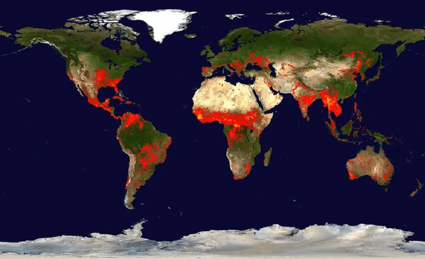
While most people associate satellite imagery with maps and weather forecasts, a lesser-known but powerful tool is making waves in the world of open-source investigations: NASA’s Fire Information for Resource Management System (FIRMS). Originally designed to track wildfires, this system is now being used to monitor conflict zones—revealing clues about frontline battles, troop movements, and possible war crimes.
🔎 What Is FIRMS?
FIRMS collects thermal data from satellites equipped with MODIS and VIIRS sensors. These instruments detect heat on the Earth’s surface, identifying so-called “hotspots” — areas that could be anything from wildfires to explosions, artillery fire, or even scorched buildings.
It sounds simple, but the implications are powerful: when missiles or heavy fighting cause fires, FIRMS can “see” them from orbit.
🔥 Fire Trails of War
In Ukraine, researchers compared FIRMS data with real-time military reports during Russia’s invasion. What they found was astonishing: the fire data matched the advance of the frontlines. With every detected fire, they could trace potential combat zones—even when social media posts or on-the-ground footage were missing.
The tool’s strength became even more apparent during Ethiopia’s brutal conflict in the Tigray region. With internet blackouts and restricted access, journalists and analysts turned to FIRMS. They mapped out hotspots across roads and towns, correlating them with official military reports and witness testimonies. This digital fire trail aligned with government troop movements, and in some cases, raised red flags about potential human rights abuses.
⚠️ The Caveats
Of course, FIRMS isn’t perfect. A fire doesn’t always mean fighting. Agricultural burning, industrial heat sources like cement kilns, and even reflective surfaces can trigger false readings. Likewise, some small or brief fires might be missed if they occur between satellite passes or under thick cloud cover.
That’s why investigators often combine FIRMS data with Sentinel Hub, Google Earth, or commercial satellite providers like Planet Labs and Maxar. The idea is to cross-reference and contextualize—matching fire data with visual smoke plumes, destruction patterns, or footage from the ground.
🌍 Open Source, Open Eyes
What makes this so empowering is that FIRMS is free and public. Anyone—from journalists and researchers to students and citizen sleuths—can access the data and use it to uncover the truth.
In fact, platforms like Bellingcat have published in-depth guides showing how to work with FIRMS data, how to visualize it in Google Earth, and how to read between the thermal lines.
Their full article, “Scorched Earth: Using NASA Fire Data to Monitor War Zones,” is a must-read for anyone curious about this field. It dives deep into real-life examples from Ukraine and Ethiopia, showing how digital fire data is shaping modern war reporting.
📖 Read it here
🔥 Final Thoughts
In a world where misinformation often spreads faster than facts, tools like FIRMS offer a layer of truth that’s hard to censor. It’s not just about fire—it’s about accountability, transparency, and the creative use of technology to seek justice.


Post Comment