9M2PJU
amateur radio
amateur radio calculator
antenna
coverage
ham radio
radio amatur
9M2PJU PRO SIGNAL, 9M2PJU signal tool, amateur radio coverage map, amateur radio field analysis, amateur radio signal visualization, HAAT estimation tool, ham radio planning tool, ham radio signal mapping, interactive RF coverage map, knife-edge diffraction mapping, map-based signal propagation, mobile RF coverage dashboard, Okumura-Hata coverage model, professional ham radio coverage, real-time RF signal map, RF propagation tool, signal path loss calculator, terrain shadowing map, terrain-aware RF analysis, VHF UHF SHF coverage map
9M2PJU
0 Comments
9M2PJU PRO SIGNAL
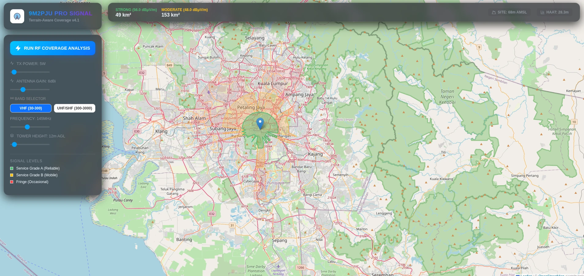
Professional Terrain-Aware RF Coverage for Amateur Radio Operators
Understanding how far your signal truly reaches is essential for modern amateur radio operations. 9M2PJU PRO SIGNAL transforms signal analysis with a high-performance, terrain-aware coverage engine designed for operators who demand accuracy, insight, and actionable field data.
Unlike conventional tools that rely on simple circular coverage estimates, PRO SIGNAL uses real-time terrain data and advanced propagation modeling to show where your RF signals genuinely reach—and where they are blocked.
🏔️ Precision Terrain Shadowing
PRO SIGNAL employs a 72-radial sampling grid combined with the Open-Elevation API to analyze topography and obstacles along each path. Using knife-edge diffraction and the Okumura-Hata suburban model, it accounts for:
- Hills, ridges, and buildings
- Signal shadowing and diffraction effects
- Dead zones and low-signal areas
The result is a realistic, map-based visualization that lets operators see exactly where their signals perform best.
📱 Native Mobile Experience
The dashboard is fully optimized for mobile use, allowing operators to perform field analysis on the go:
- Swipe-up bottom sheet: Quick access to settings without obstructing the map
- Floating Scan Button (FAB): One-tap signal coverage scanning
- Haptic-ready metrics: Large, touch-friendly cards display area statistics
With mobile-first design, PRO SIGNAL brings desktop-grade analysis to handheld devices.
📶 Multi-Band RF Performance
Whether you operate VHF, UHF, or SHF, PRO SIGNAL delivers:
- Frequency range support: 30 MHz – 3 GHz
- Automatic Height Above Average Terrain (HAAT) estimation
- Real-time service-grade mapping across multiple tiers:
| Grade | Signal Level (dBm) | Reliability | Usage Context |
|---|---|---|---|
| A | > -93 dBm | 95%+ | Handheld / HT |
| B | > -105 dBm | 70% | Mobile / Occasional |
| Fringe | > -115 dBm | <50% | Base Station / High-Gain |
This provides a clear and actionable understanding of your coverage in every operational context.
🔬 Advanced Signal Modeling
PRO SIGNAL combines mathematical rigor with intuitive visualization:
- Okumura-Hata propagation model for median path loss
- HAAT calculation sampling 8 points per radial to estimate true antenna height
- Knife-edge diffraction to model shadowing over terrain obstacles
The outcome is scientifically grounded coverage data, delivered in a visually digestible, interactive format.
🗺️ Real-Time Coverage Visualization
- Interactive Leaflet map shows terrain-aware signal propagation
- Multi-layer support highlights signal grades, dead zones, and coverage gaps
- Dynamic scanning lets you assess new locations in seconds
With PRO SIGNAL, every operator can make data-driven decisions about antenna placement, power, and operational strategy.
🛠️ Cutting-Edge Technology Stack
- Core: React 18, Vite JS
- GIS & Mapping: Leaflet, Open-Elevation API
- Design: Glassmorphism + mobile-native UI components
- Logic: Custom Hata-Okumura terrain-blocking engine
- Icons: Lucide-React
This ensures high performance, modern aesthetics, and responsive, reliable operation across all devices.
🎯 Why 9M2PJU PRO SIGNAL?
For amateur radio operators, coverage maps are more than visuals—they’re operational intelligence. PRO SIGNAL lets you:
- Understand true signal reach
- Identify terrain-limited areas
- Optimize antenna placement
- Plan mobile and portable operations with confidence
It’s professional-grade RF analysis, tailored for modern field use and powered by real-time terrain data.
Explore your coverage now: coverage.hamradio.my
73 de 9M2PJU

Post Comment