free open source software
github
mapping
CustomMaps, digitalmapping, EmbeddedMapping, geospatial, GIS, MapLibre, MapLibreGL, MapLibreNative, MappingSoftware, MapRendering, MapStyling, Maputnik, mapvisualization, MartinTileServer, mbtiles, mobilemapping, offlineMaps, offlineNavigation, OpenMapping, OpenSourceGIS, opensourcemaps, openstreetmap, PMTiles, PostGIS, RustGIS, SelfHostedMaps, TileServer, VectorTiles, WebGIS, WebMapping
9M2PJU
0 Comments
MapLibre: The Open-Source Engine Behind Modern Mapping
When you look at a map on a website or app today, there’s a good chance it’s powered by a proprietary service — with closed APIs, usage limits, and increasing costs. But there’s a growing, community-driven alternative making waves in the world of digital cartography: MapLibre.
If you’re building apps, websites, or embedded systems that rely on mapping, MapLibre offers a fully open-source, high-performance, and modern solution — maintained by a passionate community and free from the constraints of commercial licensing.
What is MapLibre?
MapLibre is an umbrella organization for several open-source mapping libraries designed to bring powerful, customizable map rendering capabilities to your project — whether it’s on the web, mobile, desktop, or even embedded systems.
The name MapLibre comes from “map” and libre (meaning “free” in several languages), which captures its spirit: open, accessible, and community-led.
Core Projects Under MapLibre
Here’s a breakdown of what makes MapLibre tick:
🧭 MapLibre GL JS
This is the web library. It’s a TypeScript-based version of the original Mapbox GL JS (v1), continued after Mapbox moved its code private.
- Designed for modern web apps
- Uses GPU-accelerated vector tile rendering
- Perfect for fast, interactive, scalable maps
- Easily integrated with frameworks like React, Vue, or plain JavaScript
👉 Use it to publish stunning, custom-styled maps directly on your website.
📱 MapLibre Native
If you’re building mobile or desktop apps, this is your toolkit.
- C++ based, with bindings for Android (Java/Kotlin) and iOS (Swift/Obj-C)
- Works on desktop and embedded devices too
- GPU acceleration via OpenGL or Metal
Whether you’re building an app for hikers, logistics, or offline navigation, MapLibre Native gives you native performance and offline capabilities.
🎨 MapLibre Style Specification
Every good map needs a style. The MapLibre Style Spec defines how your maps look — colors, labels, icons, layers, zoom levels, and more — in JSON format.
It’s compatible with many style editors like Maputnik, and follows the familiar structure pioneered by Mapbox. Whether you want a clean grayscale basemap or a colorful terrain map, this spec is the key.
🧰 Bonus Tool: Martin
Martin is a high-performance tile server written in Rust — built to serve vector tiles from PostGIS, PMTiles, or MBTiles. It’s designed for:
- Low-latency tile delivery
- Heavy traffic
- Large geospatial datasets
If you’re self-hosting your maps, Martin + MapLibre = a powerful stack.
Why MapLibre?
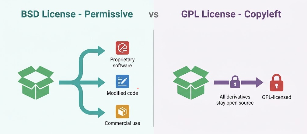
- No licensing restrictions or surprise usage fees
- Offline-capable and fully self-hostable
- Active, transparent community development
- Backed by sponsors and used in production by serious projects
- Plug-and-play with modern data pipelines (like PostGIS + tiles)
A Thriving Open Mapping Ecosystem
Beyond the core libraries, MapLibre’s GitHub organization includes tools, examples, demos, and a curated list of awesome resources. The project is under active development and welcomes contributions from developers, designers, GIS pros, and enthusiasts.
If you’re serious about maps — and you value openness, control, and performance — MapLibre is a project worth watching and using.
Learn more:
🌐 maplibre.org
🐙 GitHub: MapLibre
📦 Style Editor: Maputnik
⚡ Tile Server: Martin on GitHub


Post Comment