XASTIR – An Opensource APRS application
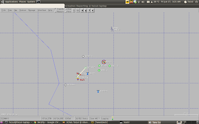
Automatic Packet Reporting System (APRS™) (also known as “Automatic Position Reporting System”) is an amateur radio based digital communication system for real-time exchange of digital information to users on the network. APRS was originally developed by Bob Bruninga, WB4APR more than 20 years ago. It has since evolved into a robust system of interconnected networks. Xastir is a computer application that provides client access to this network using the APRS protocol.
Xastir is an open source software project maintained by Developers and Contributors from all over the globe and is provided free under the GNU General Public License. From its early beginnings, Xastir has evolved into a very robust client with a rich feature set that rivals any other APRS client.
Xastir APRS Client is a FREE! software program that will run on several different operating systems, including Linux and Windows. Amateur Radio operators trained in the use of Xastir run the program which is attached to two-way amateur radio and TNC (radio modem). The Xastir software program is backed by active developer and user communities.
A few features of Xastir
- Connection with the Internet and several TNCs possible
- Support of the AX.25 kernel driver
- Logging of all data
- Vector and pixel maps
- Overlay of maps possible
- Storable map views
- Speech output for special events with sound files
- Speech output with speech synthesis
- Extensive display configuration
- The following map formats are supported in the moment
- Vector maps in WinAPRS format
- Maps in GeoTIFF format (with GeoTiff library)
- Pixel maps as xpm file
- American county maps for weather alerts
- Graphics file in 68 different formats, e.g. gif (with ImageMagick)
- Shape files





Post Comment