amateur radio
compass
ham radio
magnetic
navigation
outdoor
radio amatur
survival
compass rose, dry compass, earth geomagnetism, fluxgate compass, gimbal suspension, gyrocompass, history of the compass, how a compass works, kelvin compass, kelvins balls, magnetic compass, magnetic declination, magnetic deviation, navigation history, orienteering compass, putting the red in the shed, shen kuo, sinan south pointing spoon, true north vs magnetic north, wujing zongyao
9M2PJU
0 Comments
Navigating the Unseen: The Science, History, and Mastery of the Magnetic Compass
For thousands of years, traveling across vast oceans or featureless deserts was a gamble against fate. Navigators were bound to the visibility of the coastline, the predictable track of the sun, or the clarity of the night sky. If a storm rolled in or fog blanketed the horizon, blind wandering was the only option.
That changed with the mastery of a subtle, invisible force: Earth’s geomagnetism. The invention of the magnetic compass did not just change how we travel; it reshaped the global economy, warfare, and human connectivity forever.
The Core Physics: How a Compass Works
At its simplest, a magnetic compass is a small, lightweight magnet balanced on a nearly frictionless pivot point. This magnet, usually shaped like a needle, is free to align itself with the ambient magnetic field. Because the Earth behaves like a giant bar magnet with its own north and south magnetic poles, the needle rotates until its magnetic north pole points toward the opposite magnetic pole of the Earth.
The Dynamo Beneath Our Feet
The force guiding a compass needle does not come from the surface of the planet; it originates thousands of miles below. Deep inside the Earth, the churning and convection of liquid iron and nickel in the outer core create electrical currents. This movement acts like a massive planetary dynamo, generating a complex, protective magnetic field that blankets the globe. Without this liquid metal engine, our planet would lack a magnetic field, rendering the compass useless and leaving the surface vulnerable to solar radiation.
The magnetic field lines exit the Earth near the southern geographic pole and loop around the planet to re-enter near the northern geographic pole. A compass needle aligns parallel to these lines of force. In mid-latitudes, these lines run somewhat horizontal to the surface, allowing a standard compass to spin freely and point the way. However, as a traveler moves closer to the magnetic poles, the magnetic lines begin to dip sharply into the earth, causing compass needles to tilt downward or sluggishly drag against their housings.
The Origin: Ancient China (2nd Century BCE – 11th Century CE)
The story begins with lodestone, a naturally magnetized mineral of iron (magnetite). Ancient peoples noticed that when suspended or placed on a smooth surface, pieces of lodestone would always realign themselves along a north-south line.
Feng Shui and Mysticism (Han Dynasty)
Initially, this phenomenon wasn’t used for travel at all. During the Han Dynasty, the Chinese used lodestone to construct divination boards to harmonize environments and fortune-tell according to Feng Shui.
The earliest known design was the “South-Pointing Spoon” (or Sinan). A spoon carved from lodestone was placed on a smooth, highly polished bronze plate. When spun, the heavy handle of the spoon would reliably settle pointing directly South.
A modern replica of the Han Dynasty ‘South-Pointing Spoon’ (Sinan)
The Leap to Practical Navigation (Song Dynasty)
By the 11th century, Chinese scholars figured out how to artificially magnetize iron needles by rubbing them against lodestone or through heating and quenching.
The Wujing Zongyao (Military Compendium), written in 1044, describes a “south-pointing fish” used to find direction. By 1088, scientist Shen Kuo wrote the first explicit description of a magnetized needle being used for actual navigation. These early maritime compasses were “wet compasses”, a magnetized needle pushed through a piece of straw or cork, floated in a bowl of still water.
Spread and Evolution (12th – 14th Century)
The technology rapidly spread westward via the Silk Road and maritime trade routes, reaching the Indian Ocean, the Islamic world, and Western Europe by the late 12th to early 13th century.
Once it arrived in Europe, navigators made several critical engineering upgrades that turned the simple floating needle into a rugged, reliable field instrument.
The Dry Compass (c. 1300) – Mediterranean mariners replaced the awkward water bowl with a pivot-mounted needle inside a sealed glass box. This meant the needle could bounce around freely without water spilling during rough seas.
The Compass Rose (14th Century) – Navigators attached a circular card marked with the cardinal directions directly to the pivoting needle. Instead of watching a needle point to north and guessing the angle, the entire card rotated, allowing sailors to read their heading instantly.
The Gimbal Suspension (c. 1500) – To solve the issue of ship movement throwing off the reading, the compass box was suspended inside nested rings (gimbals). No matter how violently the ship pitched or rolled, the compass remained perfectly level.
Solving the Shipwreck Problem (19th Century)
As the world transitioned from wooden ships to massive iron and steel hulls in the 1800s, navigators hit a deadly snag: the ships themselves were magnetic. The massive chunks of iron in the hull, engines, and cargo created local magnetic fields that caused compasses to give false readings, a phenomenon known as magnetic deviation.
This was solved by two major innovations:
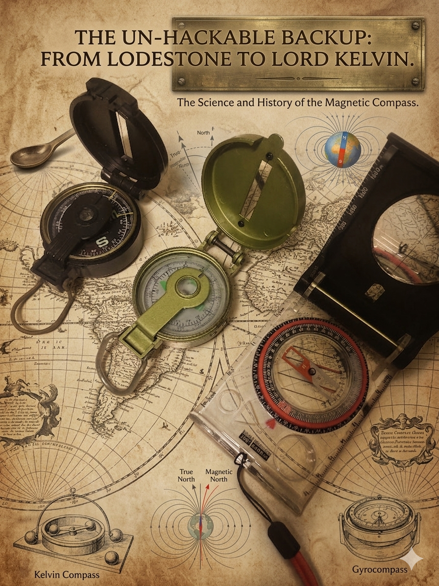
- The Kelvin Compass (1870s): William Thomson (Lord Kelvin) introduced a lightweight compass card suspended by silk cords, alongside adjustable iron spheres (called Kelvin’s balls) and magnets placed around the binnacle (the compass housing). These external iron pieces counteracted the ship’s own magnetic pull, neutralizing the errors.
- Liquid-Damped Compasses: Filling the compass bowl with a mixture of alcohol and water (and later oil) stabilized the needle or card, absorbing the vibration of the ship’s engines and heavy waves.
The Modern Era
While commercial ships and aircraft today rely on satellite-based GPS and electronic Gyrocompasses (which use the Earth’s rotation rather than magnetism to find True North), the basic magnetic compass remains the ultimate, un-hackable backup tool for survivalists, pilots, hikers, and mariners worldwide.
True North versus Magnetic North
To navigate effectively, a traveler must understand a crucial rule of geology: the compass lies. Or rather, it tells its own version of the truth. A compass needle does not point to the actual top of the world. Instead, it highlights the distinction between two different forms of North:
- True North (Geographic North): This is the absolute physical top of the Earth, located at 90 degrees N latitude. It is the fixed point where all longitudinal lines meet, defined permanently by the axis on which the planet spins. Maps, aeronautical charts, and global positioning system grids are aligned strictly to True North.
- Magnetic North: This is the point on the Earth’s surface where the planet’s magnetic field points vertically straight down. Because it is generated by moving liquid metal in the core, Magnetic North is not static. It drifts constantly, moving by tens of kilometers every year across the Arctic region toward Siberia.
| Feature | True North | Magnetic North |
| Determined by | Earth’s rotation (spin axis) | Earth’s magnetic field (molten core) |
| Location | Fixed at the top of the globe | Constantly shifting |
| Map Grid Alignment | Perfectly aligned with map grids | Offset from map grids |
| Primary Tool | GPS, Stars (such as Polaris) | Traditional Magnetic Compass |
Because these two points do not share the same physical location, an observer standing on the surface of the earth will almost always perceive an angular difference between them. This gap forms the cornerstone of professional land and sea navigation.
The Concept of Magnetic Declination
The angle between True North and Magnetic North from your specific position on Earth is called magnetic declination, which is also referred to as magnetic variation in marine aviation contexts.
If you stand in a location where Magnetic North lines up perfectly behind True North, you are standing on what is known as an agonic line, and your declination is exactly 0 degree. Anywhere else on Earth, you must adjust your calculations to compensate for the offset:
- Easterly Declination: This occurs when magnetic north sits to the east of true north, representing a positive error value.
- Westerly Declination: This occurs when magnetic north sits to the west of true north, representing a negative error value.
To translate what you see on a topographic map to what you read on your handheld compass, navigators rely on a mathematical baseline:
TRUE BEARING = MAGNETIC BEARING + DECLINATION
When managing these calculations manually, easterly declination is added as a positive number, while westerly declination is subtracted as a negative number.
Failing to account for declination can be catastrophic. An error of just 1 degree can throw a traveler off course by roughly 100 feet for every mile traveled. Over long maritime voyages or wilderness treks spanning dozens of miles, this small error compounds until a ship or hiking party is completely lost, miles away from its intended destination.
Furthermore, because the Earth’s core is dynamic, declination values for any given coordinate change over time. A topographic map printed in 1980 will list a declination value that is significantly outdated today. Modern cartographers must routinely update maps, and aviators must track changes to runway numbering, which is based on magnetic headings.
The Iron Ship Crisis and Magnetic Deviation
In the 19th century, maritime navigation encountered a severe technological roadblock. As industrialization advanced, shipbuilders abandoned wood in favor of iron and steel hulls. They quickly discovered that the ships themselves became highly magnetized during construction due to the constant hammering of rivets while the metal was aligned with the Earth’s magnetic field.
This created an entirely new category of navigational error called magnetic deviation. Unlike declination, which is caused by the planet, deviation is caused by local magnetic interference within the vehicle itself. The massive iron hull, iron boilers, and metal cargo pulled the compass needle away from Magnetic North, rendering standard readings highly inaccurate and causing a wave of unexplained shipwrecks.
The problem was analyzed and solved by British physicist William Thomson, who was later known as Lord Kelvin, in the 1870s. He introduced an advanced compass design that flanked the ship’s binnacle with two large, adjustable cast-iron spheres, which sailors quickly nicknamed Kelvin’s Balls.
He also placed adjustable permanent magnets inside the pedestal beneath the compass. These external iron pieces and internal magnets were carefully positioned to mirror and neutralize the ship’s own magnetic pull. This allowed the central compass needle to react exclusively to the planet’s magnetic field once more.
Anatomy of a Modern Orienteering Compass
While large vessels required complex binnacles, land navigators needed something portable, lightweight, and precise. This led to the development of the modern liquid-filled orienteering compass, a design popularized by the Silva Company in the 1930s. Understanding the anatomy of this tool reveals how simple physics can be harnessed for precise wilderness travel.
- The Baseplate: A clear plastic platform that allows a navigator to see the topographic map underneath. It features rulers and scale lines along the edges to measure distances accurately.
- The Compass Housing: A circular, rotating capsule that contains the magnetic needle and a damping liquid, usually a specialized oil or spirit. The liquid prevents the needle from shaking violently, allowing it to settle quickly even while the user is walking.
- The Orienteering Lines: Parallel lines printed on the bottom of the housing capsule. These are designed to align with the vertical longitudinal grid lines on a map.
- The Orienting Arrow: A distinct arrow outline printed inside the capsule floor, often referred to by outdoorsmen as the shed.
- The Magnetic Needle: A dual-colored needle where the red end points toward Magnetic North.
- The Index Line: A small marker located at the top of the housing that indicates the bearing or heading the user intends to follow.
- The Direction of Travel Arrow: An arrow printed on the baseplate pointing away from the user, indicating the direction to walk once the compass is set.
To use this tool alongside a map, a navigator utilizes a technique colloquially known as putting the red in the shed. The user aligns the clear baseplate along the desired path on the map, rotates the housing capsule until the internal orienteering lines match the map’s grid lines, and then holds the compass flat in their hand. By turning their entire body until the red magnetic needle rests perfectly inside the orienting arrow outline, the direction of travel arrow points precisely toward the destination.
Advanced Applications and Modern Alternatives
In the modern era, high-tech transportation systems require navigation tools that operate independently of local magnetic variations and electronic interference. This requirement led to the creation of advanced instruments that have largely replaced the magnetic needle on commercial and military craft.
The Gyrocompass
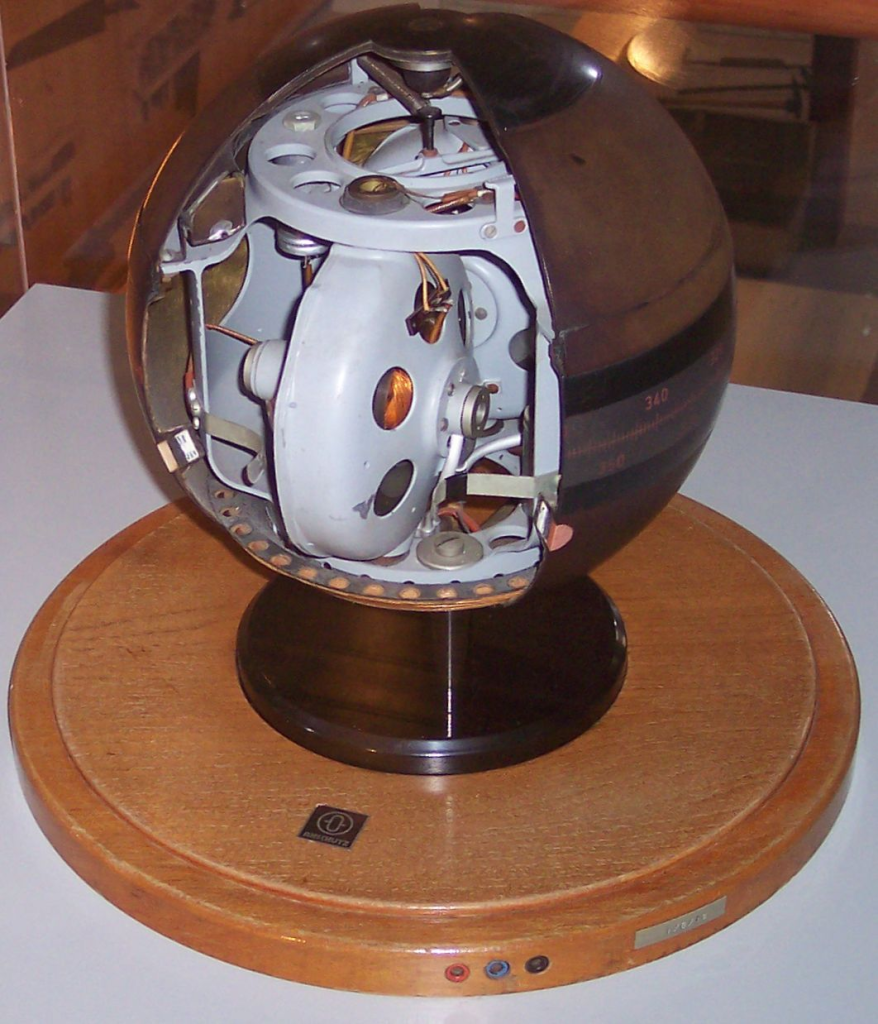
Unlike a magnetic compass, a gyrocompass contains no magnetic components and ignores the Earth’s magnetic fields entirely. Instead, it relies on a rapidly spinning, heavy wheel mounted in gimbals, utilizing the physics of gyroscopic precession and the rotational movement of the Earth.
When spun up, a gyrocompass naturally aligns itself directly with True North. This makes it immune to magnetic deviation from iron hulls, unaffected by shifting magnetic poles, and highly reliable for submarines operating deep underwater or large container ships navigating polar regions.
Fluxgate Compasses

For electronic systems, traditional needles are impractical. Modern aircraft and yachts utilize fluxgate compasses. These devices use two or more small coils of wire wound around a highly permeable magnetic core.
When an alternating electrical current passes through the coils, the earth’s natural magnetic field alters the electrical output of the circuits. A microprocessor analyzes these subtle changes to calculate the vessel’s magnetic heading instantly, transmitting the data to digital autopilots and radar screens.
Global Navigation Satellite Systems (GNSS)
The widespread adoption of GPS and other satellite networks has fundamentally altered how humanity tracks movement. By calculating the precise time it takes for signals to travel from multiple orbiting satellites to a receiver on Earth, these systems can pinpoint a user’s location within centimeters, providing an accurate true heading based on actual movement across geographic coordinates.
The Indispensable Backup
With the proliferation of smartphones, digital smartwatches, and satellite communication devices, it is easy to view the traditional magnetic compass as an obsolete relic of the past. However, military survival experts, wilderness search and rescue teams, and maritime authorities continue to mandate rigorous training in traditional map and compass skills.
The reason for this persistence is simple: digital systems are vulnerable. A solar flare can disrupt satellite signals, cyber warfare can jam GPS frequencies, and cold weather or water immersion can destroy lithium-ion batteries. An electronic device can fail at a critical moment, leaving a traveler blind in an unfamiliar environment.
A magnetic compass requires no external power source, features no software to crash, cannot be hacked, and relies entirely on the permanent geological engine of the planet. So long as the Earth continues to spin and its liquid iron core continues to churn, the humble magnetic needle will remain the ultimate, un-hackable backup tool for finding the way home.
Compass Usages For Amateur Radio (Ham Radio)
For amateur radio (ham radio) operators, a dependable magnetic compass is a vital, low-tech tool that bridges the gap between geography and radio wave propagation. Its primary and most frequent application is in the precise alignment of directional antennas such as Yagis, hexbeams, or satellite dishes. To maximize signal strength and successfully establish long-distance contacts (DXing), an operator must rotate their antenna toward the exact bearing of the target station. While modern operators often use digital rotators or computer software to calculate these headings, a handheld compass serves as the ultimate ground-truth reference for calibrating those systems during field setup, ensuring that “True North” on the rotator controller actually matches the physical world. This calibration becomes especially critical during portable operations like Parks on the Air (POTA) or Summits on the Air (SOTA), where hams hike into remote areas with lightweight gear and must manually orient their temporary wire antennas or portable beams to face major population centers or specific grid squares.
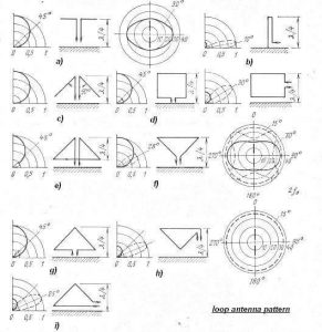
Furthermore, in the high-stakes world of amateur radio direction finding (ARDF) colloquially known as “fox hunting”. Operators actively track down hidden or unauthorized transmitters. During a fox hunt, hams use a directional antenna paired with a compass to take multiple bearings from different physical locations; by plotting these magnetic headings on a topographic map, they can use triangulation to pinpoint the exact coordinates of the hidden signal. Finally, in emergency communications (EmComm) scenarios where cell towers are down, internet access is nonexistent, and GPS units may fail due to dead batteries or satellite disruptions, a simple magnetic compass ensures that a radio operator can still navigate safely, establish emergency point-to-point radio links, and accurately report their position to search and rescue teams, proving itself to be an indispensable, un-hackable backup tool in any ham’s go-kit.


Post Comment