amateur radio
APRS
automatic packet reporting system
ham radio
radio amatir
radio amatur
9M2 stations, 9m2pju, amateur radio malaysia, APRS digipeater map, aprs map, aprs messaging, APRS mobile, APRS web client, aprs-is, aprs.fi alternative, APRS.world, browser APRS, CWOP weather APRS, EMCOMM APRS, ham radio map, ham radio tracking, live callsign tracker, real time APRS, SOTA tracking, track ham radio
9M2PJU
4 Comments
APRS.world: The Browser-Based APRS Map That’s Changing How Hams See the World
If you are in amateur radio, you know APRS. Automatic Packet Reporting System lets us track vehicles, send short messages, share weather data, and follow high altitude balloons. It runs over RF and the internet.
The problem is that most APRS software feels stuck in 90’s. You need to install it, configure soundcards, and fight with COM ports. APRS.world changes that. It gives you a free, modern, live map. No downloads required.
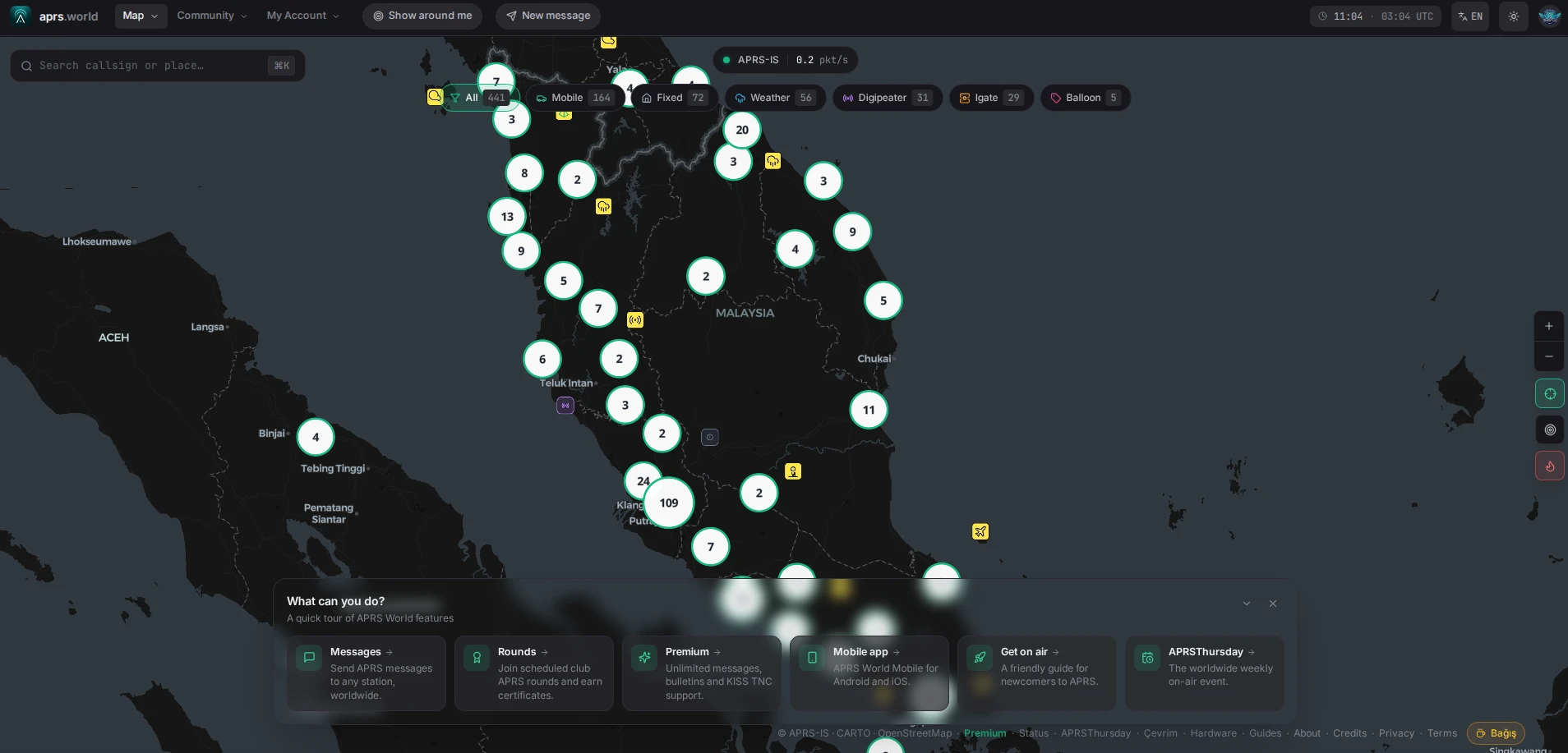
What Is APRS.world?
APRS.world is a real time map and callsign tracker for the global APRS network. It connects directly to the live APRS-IS internet feed. That means every beacon, message, and weather packet that reaches the global servers appears on your screen in seconds.
There is no installer. There are no config files. There is no need to set up virtual audio cables. Open https://aprs.world on your phone or laptop and you are looking at the entire planet, live.
7 Reasons Hams Are Switching to APRS.world
1. Track Any Callsign Instantly
Type 9M2PJU-9 in the search box and you jump straight to the last known position. You get speed, altitude, course, symbol, and the comment text. This is perfect for checking if your friend got home safely or for following your own APRS beacon during a road trip from Shah Alam to Kuantan.
2. One Click for “Stations Near Me”
Tap the location icon and APRS.world finds all active APRS stations around you. This is useful for VHF simplex testing, local nets, or identifying that new digipeater in Selangor you keep hearing.
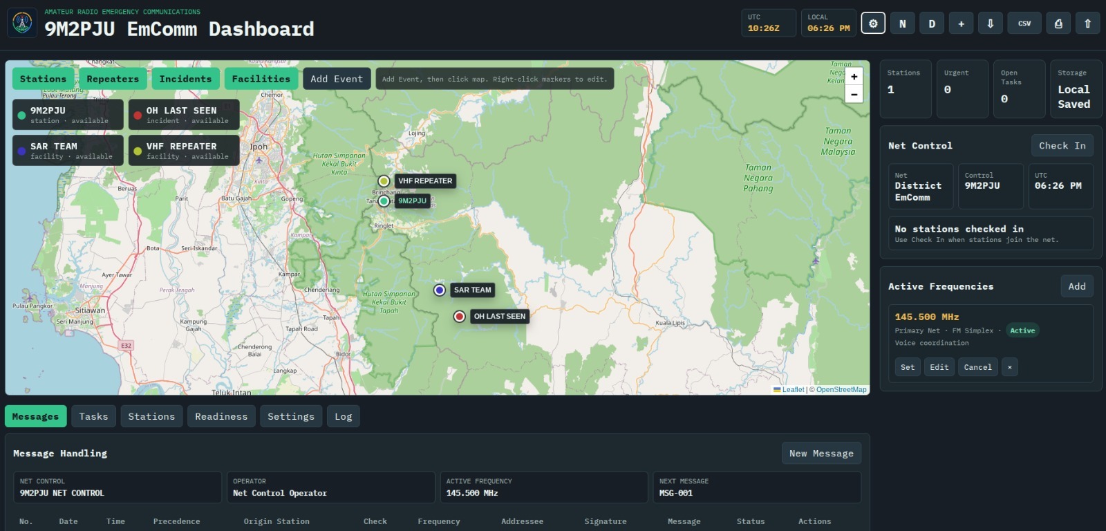
3. Send APRS Messages From Your Browser
No radio with you? You can still send APRS messages from the web interface. This is a big deal for EMCOMM. Net control can message field teams even if they are out of RF range, as long as they have internet. You authenticate with your callsign to keep the system clean.
4. Live Weather and Telemetry Overlay
Thousands of CWOP weather stations report to APRS. APRS.world plots them with temperature, wind, and rainfall data. Click any station and you get historical graphs. Storm chasers and hikers use this for real time ground truth.
5. Satellite, Terrain, and Dark Mode
The map is not just a basic grid. Switch to satellite view to confirm if that SOTA station is truly on Gunung Nuang. Dark mode protects your eyes during late night nets. The site is smooth on mobile. No app needed.
6. Multi Language Support
APRS is global, so the tool should be global too. The UI is available in English, Japanese, Spanish, German, French, and several other languages. More languages get added based on community demand.
7. Free to Use. No Account Needed for Viewing
You only log in if you want to send messages. If you just want to view and track, the site is wide open. That matches the spirit of amateur radio.
How People Use APRS.world in the Real World
| Who | How They Use It |
|---|---|
| 4×4 Clubs | Share one link so family can follow a convoy through Gombak to Janda Baik in real time |
| Event EMCOMM | Marathon organizers track sweep vehicles and aid stations without special software |
| SOTA and POTA Activators | Spotters watch your beacon to know when you reach the summit and start calling CQ |
| STEM Teachers | Show students live data. For example, that moving dot is 9M2PJU mobile right now |
| Off Grid Travelers | Family back home can see your last beacon if you go silent on HF |
APRS.world vs Traditional APRS Software
| Feature | APRS.world | Legacy Desktop Software |
|---|---|---|
| Setup time | Zero. Open the URL and go | 30 minutes or more. Install, soundcard, AGWPE |
| Platform | Any browser. iOS, Android, Mac, Linux | Mostly Windows only |
| Live data | Direct APRS-IS feed | Often delayed or filtered |
| Messaging | Send from the web | Requires RF or a complex iGate setup |
| Mobile use | Responsive interface | Difficult or impossible |
| Cost | Free | Some tools are paid or donationware |
3 Pro Tips for APRS.world
- Bookmark direct callsign links. Use
https://aprs.world/?call=9M2PJU-9to jump straight to your station. This is great for sharing with family. - Use filters. Hide or show vehicles, weather stations, digipeaters, or objects so the map stays clean during big events like Le Tour de Langkawi.
- Watch the age colors. Beacons fade from red to yellow to grey as they get older. If a station is grey, it has not been heard in a while.
The Bottom Line
APRS used to mean tinkering with settings. APRS.world means you can just use it. Whether you are running communications for a public service event, tracking yourself on a motorbike tour, or just curious about ham activity in 9M2 right now, this is the fastest way to see it.
It respects the core of amateur radio. It is open, global, and experimental. The only difference is that the user experience finally feels like it belongs in 2026.
Try it now: https://aprs.world
APRS.world represents a significant advancement in the accessibility and functionality of APRS mapping. Unlike traditional software that often requires complex configurations, this browser-based platform allows users to engage with real-time APRS data effortlessly. Its intuitive interface and open access align seamlessly with the fundamental principles of amateur radio, fostering a sense of community among users. By providing a modernized approach to tracking and communication, APRS.world invites both seasoned and novice hams to explore and utilize the vast potential of APRS technology.


4 comments