9M2PJU
amateur radio
free software
ham radio
malaysia
map
peninsular
radio amatur
9m2pju map tool, apers tracking map malaysia, bukit kertau origin datum, client side coordinate converter, epsg 3168 conversion, everest 1830 modified ellipsoid, free geodetic math tool, grid easting northing calculator, ham radio mapping tool, hotine oblique mercator malaysia, jupem coordinate transformation, jupem map coordinate converter, kertau rso malaya, kertau.hamradio.my, lat long to rso converter, malayan revised triangulation, malaysia coordinate converter, mrso map projection, mrt48 to gdm2000, open source geodetic transformation malaysia, peninsular malaysia grid meters, qgis malaysia rso grid, rso geocentric parameters, rso malaya easting northing, wgs84 to kertau 1968
9M2PJU
0 Comments
9M2PJU Lat Long to Kertau RSO Malaya Converter
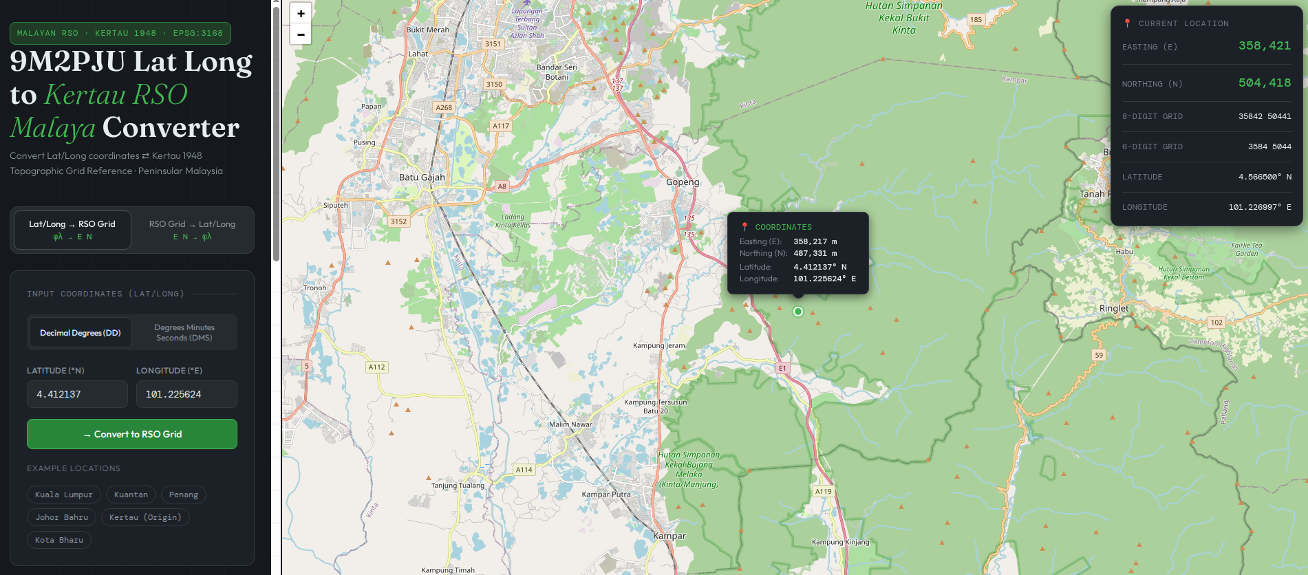
If you work with mapping, emergency communications, forestry, or land surveying in Peninsular Malaysia, you have definitely run into this frustrating issue: your GPS gives you standard Latitude and Longitude, but your local topographic paper maps demand Kertau RSO Malaya coordinates (Easting and Northing in meters).
Bridging the gap between modern smartphone GPS data and Malaysia’s legacy map grids used to mean opening heavy, complicated GIS software.
Not anymore. Introducing 9M2PJU Lat Long to Kertau RSO Malaya Converter, ultra-lightweight web tool that solves this exact problem: the Lat Long to Kertau RSO Malaya Converter, available right now at kertau.hamradio.my.
Why Does Kertau RSO Malaya Exist?
You might wonder why we don’t just use standard global coordinates for everything. The short answer is: the Earth is not a perfect round ball, and global systems like WGS 84 cause distortion when flattening a specific country onto a 2D map.
- The Historical Anchor: Back in the mid-20th century, surveyors anchored Malaysia’s mapping system to a specific geographic point: the primary geodetic station at the top of Bukit Kertau in Temerloh, Pahang.
- The Slanted Grid (RSO): Standard map grids use vertical, north-south strips. But Peninsular Malaysia is naturally tilted from northwest to southeast. To prevent massive map distortion at the edges of the country, cartographers created the Rectified Skew Orthomorphic (RSO) projection. It tilts the map layout at an angle to perfectly match the natural shape of the peninsula, keeping scale measurements incredibly accurate.
Because of this tailored precision, Kertau RSO remains the backbone of local forestry, search and rescue (SAR), and older government topographic maps.
How the Converter App Works
The math required to shift a coordinate from a global satellite system to a localized, slanted Malaysian grid is incredibly heavy. It involves moving data between two entirely different models of the Earth (the global WGS 84 ellipsoid and the local Modified Everest 1830 ellipsoid) and applying complex Hotine Oblique Mercator formulas.
- 100% Client-Side: The application utilizes fast JavaScript libraries to run the mathematical parameters right inside your web browser.
- Zero Server Lag: Because your device does the calculation locally, there is no waiting for data to travel back and forth to a distant server.
- Field-Ready Performance: The site is designed to be completely lightweight.
Try It Out and Bookmark It
Whether you are a ham radio operator tracking field coordinates, a hiker cross-referencing paper maps, or a developer looking for a clean implementation of Malaysian geodetic math, this utility is a must-have tool.
- Launch the Live Tool: Go to kertau.hamradio.my to start converting right away.


Post Comment