How to Read Latitude and Longitude on a Topographic Map
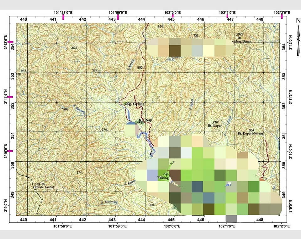
Topographic maps from JUPEM show coordinates like 101°59'0"E and 3°10'0"N along the border. Those are longitude and latitude. This guide shows how to read them using the map as an example.
1. Understand the Map Border
Top and bottom edges mark Longitude, the vertical lines. Labels read 101°58'0"E, 101°59'0"E, 102°0'0"E. The E means East.
Left and right edges mark Latitude, the horizontal lines. Labels read 3°9'0"N, 3°10'0"N, 3°11'0"N. The N means North.
Between each 1 minute line are 5 short tick marks. They divide 1 minute into 6 equal parts. Since 1 minute equals 60 seconds, each space between ticks is 10 seconds.
Rule: 60 seconds ÷ (number of short ticks + 1) = seconds per interval.
For this map, 60 ÷ 6 = 10 seconds per space.
2. Read Coordinates in the Correct Order
Coordinates are written as Latitude, Longitude. That is the same as Y, X. Move up first to find latitude, then move right to find longitude.
Worked Example: Kg. Gelang
Step 1: Find the Latitude
- Locate Kg. Gelang on the map. It sits between
3°11'0"Nand3°12'0"N. - Measure up from
3°11'0"N. The village is about 0.5 tick above the line. - Each tick equals 10 seconds, so 0.5 tick equals 5 seconds.
- Latitude =
3°11'0"N + 5" = 3°11'5"N.
Step 2: Find the Longitude
- Locate Kg. Gelang between
101°59'0"Eand102°0'0"E. - Measure right from
101°59'0"E. The village is about 1 tick to the right. - One tick equals 10 seconds.
- Longitude =
101°59'0"E + 10" = 101°59'10"E.
Result: 3°11’5″N, 101°59’10″E
3. Convert to Decimal Degrees for GPS Use
Phone maps use Decimal Degrees. Convert with:Degrees + Minutes/60 + Seconds/3600
For Kg. Gelang:
Latitude: 3 + 11/60 + 5/3600 = 3 + 0.1833 + 0.0014 = 3.1847°N
Longitude: 101 + 59/60 + 10/3600 = 101 + 0.9833 + 0.0028 = 101.9861°E
Enter 3.1847, 101.9861 into Google Maps to plot Kg. Gelang.
4. Latitude Longitude vs Grid Reference
The black numbers 443 and 352 inside the map are the RSO Malaya grid. This system uses Easting, Northing. You read right first, then up. That is the opposite of Lat Long.
| System | Read Order | Example for Kg. Gelang |
|---|---|---|
| Lat Long | Up, then right | 3°11'5"N, 101°59'10"E |
| RSO Grid | Right, then up | 4433 3521 |
Use grid references for fast local navigation. Use Lat Long for global positioning and sharing with others.
Key Points to Remember
- Read latitude first, then longitude.
- On JUPEM maps, one small tick equals 10 seconds.
- Paper map accuracy is within 50 to 150 meters. Verify with GPS for critical navigation.
- Convert to decimal degrees before entering into phones or GPS units.
Practice with known points on your map. Compare your result with a GPS to improve your accuracy.


Post Comment