Aircraft Radar for Garmin Instinct: Live ADS-B Wrist Tracking for Civilian and Military Usages
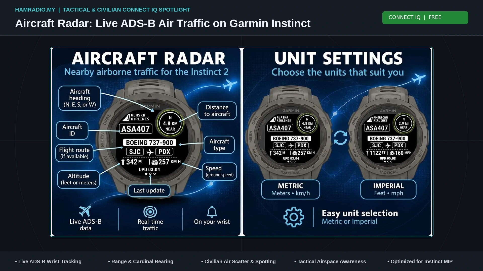
TL;DR: Aircraft Radar by Mr.Jiri is a free Garmin Connect IQ app that transforms rugged, monochrome Garmin Instinct smartwatches into wrist-mounted ADS-B air traffic monitors. By pulling real-time transponder data through a paired smartphone using the watch’s GPS location, it displays nearby aircraft callsigns, types, routes, altitudes, ground speeds, and relative bearings in the signature Instinct subscreen. From civilian planespotting and ham radio aircraft scatter propagation to military drop zone situational awareness and visual aircraft identification, this lightweight tool brings actionable airspace intelligence to your wrist.
What Is the Aircraft Radar Garmin Instinct App?
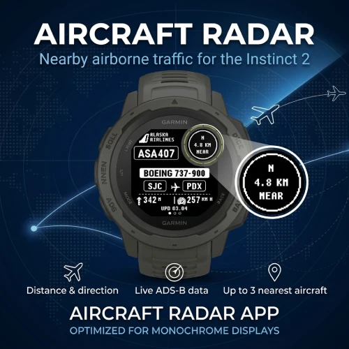
Aircraft Radar is a free Connect IQ wearable application developed by Mr.Jiri that brings real-time ADS-B flight tracking and nearby air traffic situational awareness directly to Garmin Instinct series smartwatches.
For outdoor adventurers, aviation enthusiasts, radio amateurs, and field operators, monitoring the airspace overhead traditionally meant pulling out a smartphone, unlocking the screen, and navigating a data-heavy commercial tracking application like Flightradar24 or ADS-B Exchange. While smartphone apps provide detailed vector maps and flight trajectories, they present major operational drawbacks: bright smartphone screens ruin night vision, touchscreen interfaces fail in wet weather or while wearing tactical gloves, and bright sunlight washes out conventional OLED displays.
The Garmin Instinct series was designed specifically to escape these limitations. Built to military standard MIL-STD-810G for thermal, shock, and water resistance up to 100 meters, the Instinct features a sunlight-readable, high-contrast monochrome Memory-in-Pixel (MIP) display.
Aircraft Radar uses this unique hardware platform. By translating high-density Automatic Dependent Surveillance-Broadcast (ADS-B) flight telemetry into clean, high-contrast typography, the app delivers immediate airspace intelligence at a glance of your wrist, bridging the gap between rugged outdoor wearables and tactical situational awareness.
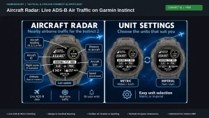
       [ Aircraft Radar Display Architecture on Garmin Instinct ]

   +-------------------------------------------------------+
   |  [ MAIN DISPLAY WINDOW ]           [ SUBSCREEN EYE ]  |
   |                                                       |
   |   AIRCRAFT TYPE BADGE: [B738]          +----------+   |
   |   CALLSIGN / AIRLINE:  RYR4512         | 14 km    |   |
   |   ROUTE:  [PRG] ──✈──> [STN]           |    NE    |   |
   |                                        +----------+   |
   |   ALTITUDE: 32,000 FT                                 |
   |   SPEED:    460 KTS / 850 KM/H                        |
   |   STATUS:   AIRBORNE (TARGET 1/3)                     |
   +-------------------------------------------------------+
Designed for the Instinct: Display Architecture and Subscreen Integration
Most third-party smartwatch apps attempt to cram full-color graphics and miniature maps onto tiny screens, resulting in cluttered interfaces that drain battery power and prove difficult to read in the field. Aircraft Radar takes the opposite approach by fully embracing the distinctive industrial design of the Garmin Instinct:
1. Dual-Window Layout and the Circular Subscreen
The hallmark of the Garmin Instinct is its secondary circular subscreen (often called “the eye”) in the top-right corner of the display. Aircraft Radar makes brilliant functional use of this partitioned layout:
- The Circular Subscreen: Dedicated entirely to spatial navigation. It calculates and displays the target aircraft’s exact slant distance from your current position (in kilometers or miles) alongside its cardinal relative bearing (such as
12km NEor7mi SW). A quick glance at the subscreen tells you exactly which quadrant of the sky to look toward. - The Main Window: Formats flight telemetry using custom high-contrast monochrome badges and outlined typography. It displays the operating airline, flight callsign, an outlined aircraft type badge (such as
A320,B738,A380,C130, orC172), route origin and destination airport codes separated by a centered aircraft icon, current altitude, and ground speed.
2. Physical Button Navigation and Target Cycling
Touchscreens are notoriously unreliable in torrential rain, freezing cold, or when wearing tactical combat gloves. Aircraft Radar relies entirely on the Instinct’s tactile physical pushbuttons:
- Users can swipe or step through up to the three closest airborne aircraft currently in the local sky using the watch’s Up and Down buttons.
- Pressing the GPS button triggers an immediate manual one-shot telemetry refresh.
3. Automatic Ground Filtering and Energy Management
Airports frequently host dozens of stationary aircraft, baggage tugs, and taxiing planes broadcasting ADS-B surface positions. Aircraft Radar automatically filters out ground clutter, ensuring that only actively airborne traffic within your visible horizon consumes memory slots.
To maintain the Instinct’s renowned weeks-long battery life, the app uses an on-demand GPS model. It captures your coordinates when opened or refreshed and immediately suspends the GPS receiver when closed or placed in the background, preventing unnecessary satellite tracking drain.
Under the Hood: Telemetry Pipeline and Data Flow
Aircraft Radar bridges low-power wearable firmware with global air traffic surveillance networks through a lightweight, highly efficient data pipeline:
[ GPS Coordinates ] ──> [ BLE Sync ] ──> [ Garmin Mobile ] ──> [ ADS-B Server ]
   Instinct Watch        Bluetooth        Paired Phone          Cloud Ingestion
                                                                       │
[ Screen Display  ] <── [ Clean JSON ] <── [ Data Filter ] <───────────┘
   3 Nearest Planes      BLE Packet         Ground Stripped
- Local Fix: When triggered, the watch records its latitude and longitude using its internal multi-GNSS receiver (or grabs the cached location from the paired smartphone).
- Bluetooth Transport: The Connect IQ runtime packages the coordinate into a background communications request passed over Bluetooth Low Energy (BLE) to the Garmin Connect Mobile app running on iOS or Android.
- ADS-B Telemetry Fetch: The phone queries public, aggregated ADS-B data endpoints. Modern aircraft continuously broadcast Mode S Extended Squitter transponder messages on 1090 MHz and 978 MHz UAT, providing GPS position, barometric altitude, ground speed, and ICAO 24-bit aircraft hex addresses.
- Parsing and Route Correlation: The cloud backend correlates the raw ICAO transponder squawk with public civil aviation databases to resolve flight numbers, operating carriers, and scheduled city pairs (departure and arrival airports).
- Monochrome Rendering: The processed payload returns to the Instinct as a compact data structure, rendering instantly on the transflective MIP screen without requiring the user to create third-party API accounts or manage subscription keys.
Civilian Usages and Everyday Applications
While tracking planes on a watch might sound like a simple novelty, Aircraft Radar provides immense practical utility across diverse civilian and outdoor pursuits:
1. Aviation Enthusiasts and Planespotters
For casual watchers and dedicated aviation photographers alike, identifying passing airliners is an instinctive reflex. Standing on a runway perimeter, rooftop, or park, you hear jet engines roaring overhead. Instead of unlocking a smartphone, shielding the washed-out glass screen from the sun, and waiting for a browser map to load, a single flick of your wrist reveals the flight’s callsign, aircraft type, cruise altitude, and destination in less than two seconds.
2. Amateur Radio Operators: VHF/UHF/Microwave Aircraft Scatter
In the amateur radio world, operators frequently exploit Aircraft Scatter (ACS) (also known as Air Scatter propagation) to complete ultra-weak signal contacts on the 2-meter (144 MHz), 70-centimeter (430 MHz), and 23-centimeter (1.296 GHz) bands.
When high-altitude commercial airliners fly through the common midpoint between two distant ham radio stations, their massive aluminum and composite airframes act as passive RF reflectors. Radio waves bounce off the moving aircraft, creating a temporary propagation path that allows VHF/UHF signals to traverse hundreds of kilometers across terrain normally blocked by curvature and mountain ranges.
       [ VHF / UHF Aircraft Scatter Propagation Geometry ]

Station A (9M2PJU)                                    Station B (Remote DX)
      \                                                      /
       \                                                    /
        \                                                  /
         ──> ──> ──>  [ COMMERCIAL AIRLINER ]  ──> ──> ──>
                      Reflective Metal Airframe
                      Altitude: 36,000 FT
                      Heading: 045° (NE)
Aircraft Radar transforms the Garmin Instinct into an indispensable field tool for portable VHF/UHF operators:
– Operators running Parks on the Air (POTA) or Summits on the Air (SOTA) can check their wrist to verify when a heavy airliner (like an Airbus A380 or Boeing 777) is approaching the optimal scatter midpoint.
– The subscreen’s real-time distance and cardinal bearing allow operators to point directional Yagi antennas directly at the reflecting target without bringing laptop tracking software into the wilderness.
3. Drone (UAS/UAV) Operators and Part 107 Pilots
Certified commercial drone pilots and recreational remote pilots must maintain visual line of sight and yield right-of-way to all manned aircraft. Low-flying helicopters, medevac air ambulances, and general aviation aircraft (such as Cessna 172s or Piper Archers) frequently enter the lower airspace corridors (below 1,000 feet AGL).
Wearing Aircraft Radar on the wrist provides remote pilots with ambient airspace awareness. Hearing an approaching engine tone, a drone pilot can quickly check the watch to see if a helicopter or light aircraft is inbound in their immediate sector, allowing them to descend and loiter safely until the airspace is clear.
4. Wilderness Backpackers and Mountaineers
Deep in national parks or backcountry mountain trails where trails are isolated and cell coverage is sparse, spotting high-altitude aircraft can provide subtle environmental clues:
– Identifying regional search and rescue (SAR) aircraft or forest service firefighting spotters operating low over a nearby ridge.
– Recognizing commercial flight corridors that indicate prevailing weather routing or proximity to major metropolitan flight paths.
Military and Tactical Usages
The Garmin Instinct Tactical editions (including the Instinct Tactical, Instinct 2 Solar Tactical, and Instinct 2X Solar Tactical) are standard-issue or privately purchased field gear for infantrymen, forward observers, and tactical aviators. Aircraft Radar adds a potent layer of auxiliary airspace situational awareness to these rugged wrist units:
1. Tactical Airspace Situational Awareness
During field training exercises, forward reconnaissance, or perimeter security operations, ground elements need to maintain continuous awareness of the airspace above them. While combat air operations utilize encrypted Link 16 tactical datalinks, routine military air transport, aerial refueling, and logistical flights routinely operate with civilian ADS-B Out enabled for airspace safety compliance.
Field operators equipped with Aircraft Radar can detect and monitor:
– Military Air Mobility: Inbound C-130 Hercules, C-17 Globemaster III, and A400M Atlas transport aircraft.
– Aerial Tankers: KC-135 Stratotankers, KC-46 Pegasuses, or KC-30As flying racetrack orbits.
– Joint / Civilian Airlift: Contracted cargo and VIP transport aircraft operating in civil airways.
2. Drop Zone (DZ) and Helicopter Landing Zone (HLZ) Coordination
Pathfinders, combat controllers, and range safety personnel managing improvised landing zones or tactical drop zones require precise timing:
– Looking down at an Instinct subscreen to confirm the distance and inbound bearing of a scheduled logistics or parachute drop aircraft keeps hands free to manage communications gear, smoke markers, or wind gauges.
– It eliminates the need to expose a glowing Android Tactical Assault Kit (ATAK) phone or bulky End User Device (EUD) while standing in exposed observation points.
3. Visual Aircraft Recognition (VACR) and Acoustical Verification
A critical task for ground observers and air defense spotters is Visual Aircraft Recognition. When an aircraft is heard breaking through cloud cover or passing behind a ridgeline, the operator can glance at the watch:
– If the app shows a civilian commercial flight matching the heading, altitude, and speed, the acoustic contact is immediately verified as non-hostile civil air traffic.
– If a low-flying high-speed jet passes overhead and no ADS-B contact appears on the watch, the operator instantly knows the target is flying dark (non-squawking or military Mode 5), alerting the team to take appropriate tactical posture.
4. Low-Observable and Night Vision Compatibility
The Garmin Instinct MIP display is passive; it reflects ambient sunlight during the day and requires zero backlight to read. At night:
– The Instinct Tactical series includes a dedicated Night Vision Mode that drops backlight intensity to levels invisible to the naked eye while remaining crystal-clear through Generation 3 Night Vision Goggles (NVGs).
– Using Aircraft Radar on an Instinct ensures that checking airspace traffic will never create a flash of stray visible light that could compromise a forward observation post.
Tactical Constraints and Operational Realities
While Aircraft Radar is a remarkably capable tool, military and tactical users must keep several critical operational limitations in mind:
- Non-Cooperative Air Assets: Fighter jets, stealth aircraft, and frontline combat sorties flying operational combat missions disable civilian Mode S/ADS-B Out or utilize encrypted military IFF (Identification Friend or Foe) Mode 4/5. They’ll never appear on public ADS-B aggregators.
- Communications Dependency: The watch app requires a Bluetooth link to a smartphone or tactical gateway device with active internet access (cellular, tactical Wi-Fi, or satellite terminals like Starlink or Iridium GO). It doesn’t contain an internal 1090 MHz SDR radio receiver.
- Radio Frequency Signature: Bluetooth Low Energy emits RF in the 2.4 GHz ISM band. In high-threat EW (Electronic Warfare) environments where radio silence or EMCON (Emissions Control) is mandated, Bluetooth transmitters must be disabled using the Instinct’s built-in Stealth Mode.
Aircraft Radar vs Alternative Airspace Tools
To put Aircraft Radar in perspective, here is how wrist-mounted ADS-B tracking compares to other common air monitoring solutions:
| Feature / Metric | Aircraft Radar (Garmin Instinct) | Flightradar24 / ADS-B Exchange App | Dedicated SDR (RTL-SDR + Laptop) | ATAK with ADS-B Plugin (EUD) |
|---|---|---|---|---|
| Form Factor | Rugged Wristwatch | Commercial Smartphone | Laptop / Raspberry Pi + Antenna | Ruggedized Tactical Phone |
| Environmental Rating | MIL-STD-810G, 100m Water | IP68 (Glass Screen Vulnerable) | Fragile Lab Equipment | MIL-STD-810H Cased Phone |
| Battery Life | Weeks (Solar Assisted) | 6 to 12 Hours | 2 to 4 Hours | 8 to 14 Hours |
| Screen Technology | Sunlight-Reflective MIP | Washout OLED / AMOLED | LCD Laptop Screen | High-Nit AMOLED |
| Night Vision (NVG) | Yes (Instinct Tactical Mode) | No (Blinding Light Signature) | No | Yes (Filtered Red/Green) |
| Hands-Free Usability | High (Wrist Mount) | Low (Handheld Phone) | None (Stationary Bench) | Medium (Chest Rig Mounted) |
| RF Reception Method | Cellular Internet via Phone | Cellular / Wi-Fi Internet | Direct 1090 MHz RF Reception | Server Datalink / Cellular |
| Cost | 100% Free App (Connect IQ) | Subscription Tier / Ads | $35 – $60 Hardware | Enterprise / Military Only |
Compatible Garmin Instinct Models
Aircraft Radar supports a wide variety of Garmin Instinct devices featuring monochrome dual-window displays, including:
- Garmin Instinct 2 Series: Instinct 2 (45mm), Instinct 2 Solar, Instinct 2 Surf, Instinct 2 Dezl.
- Garmin Instinct 2S Series: Instinct 2S (40mm), Instinct 2S Solar.
- Garmin Instinct 2X Series: Instinct 2X Solar (50mm), Instinct 2X Solar Tactical Edition.
- Garmin Instinct Crossover Series: Instinct Crossover, Instinct Crossover Solar, Instinct Crossover Tactical.
- Garmin Instinct 3 / E Series: New generation rugged Instinct wearables.
Step-by-Step Installation and Configuration
Setting up Aircraft Radar takes less than three minutes using the Garmin Connect IQ ecosystem:
Step 1: Install from Connect IQ Store
- Open the Garmin Connect IQ app on your paired iOS or Android smartphone.
- Search for
Aircraft Radaror navigate directly to the Aircraft Radar Connect IQ Store Page. - Tap Install and allow your smartphone to sync with your Garmin Instinct watch over Bluetooth.
Step 2: Grant Location Permissions
Ensure that the Garmin Connect mobile app has permission to access your smartphone’s location services (“Always Allow” or “While Using App”). This enables Aircraft Radar to calculate the relative distance and bearing to nearby aircraft even if your watch is indoors.
Step 3: Customize Preferences in Settings
In the Connect IQ app, access the settings menu for Aircraft Radar:
– Measurement Units: Choose between Metric (kilometers, meters, km/h) and Imperial (miles, feet, mph).
– Time Format: Selecting Imperial mode also toggles the timestamp display to a standard 12-hour AM/PM clock.
Step 4: Operating in the Field
- On your Instinct watch, press the GPS / Enter button to access the activities and apps menu.
- Select Aircraft Radar.
- The app will briefly display your GPS acquisition status before pulling the live ADS-B feed.
- Use the Up and Down buttons to cycle between the three nearest airborne planes.
- Check the circular subscreen to read the target’s distance and compass bearing.
- Press the GPS button at any time to execute an immediate data refresh.
Actionable Airspace Intelligence on Your Wrist
Aircraft Radar by Mr.Jiri exemplifies the true potential of the Garmin Connect IQ platform. Instead of attempting to turn a rugged outdoor watch into a poor imitation of a smartphone, it distills complex, high-velocity ADS-B transponder data into clear, mission-critical metrics optimized for the Instinct’s battle-tested display.
Whether you are an amateur radio operator calculating VHF aircraft scatter openings, a planespotter capturing tail numbers at the airfield fence, a drone pilot verifying regional airspace clearance, or a tactical operator maintaining passive airspace awareness on exercise, Aircraft Radar delivers real-time situational awareness directly to your wrist.
Sources and Further Reading
- Garmin Connect IQ Aircraft Radar App Page: https://apps.garmin.com/apps/f2885c43-51e9-40f3-bf50-6bac75854014
- Mr.Jiri Developer Profile on Garmin Connect IQ: https://apps.garmin.com/developer/67631226-0b62-4715-b386-e702ff7472fe/apps
- Flight Tracker for Garmin Watches by Mr.Jiri: https://apps.garmin.com/apps/
- Developer Buy Me a Coffee Support Page: https://www.buymeacoffee.com/flighttracker
- Garmin Instinct 2 Solar Tactical Specifications: https://www.garmin.com/
- Federal Aviation Administration (FAA) ADS-B Overview: https://www.faa.gov/air_traffic/technology/adsb
- Aircraft Scatter Propagation in Amateur Radio (ARRL Handbook Chapter 21): https://www.arrl.org/
- ADS-B Exchange Open Air Traffic Data: https://www.adsbexchange.com/
73 de 9M2PJU.



Post Comment