The Tactical Deployment of OsmAnd in Search and Rescue Operations
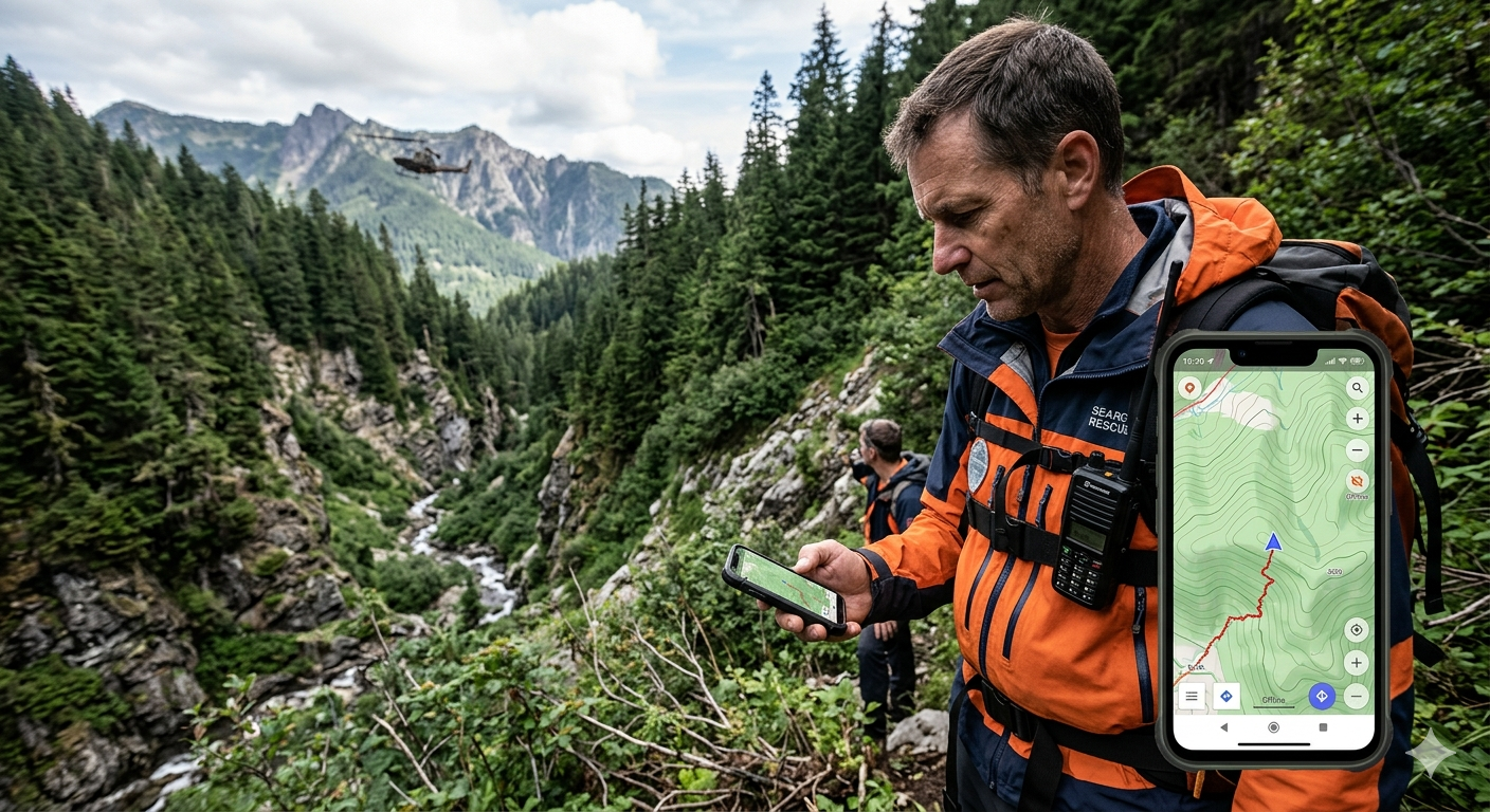
When a missing person incident escalates into a wilderness Search and Rescue (SAR) operation, standard civilian infrastructure ceases to be a viable asset. In dense jungles, deep mountain passes, and complex wilderness terrain, commercial navigation systems fail catastrophically. Applications such as Google Maps and Waze rely on persistent cellular network handshakes, remote cloud-compute rendering, and commercial point-of-interest databases. In an off-grid survival scenario, these features are non-existent.
Modern emergency management requires a local, ruggedized Geographic Information System (GIS) capable of operating under absolute communication blackouts. OsmAnd (OpenStreetMap Automated Navigation Directions) fulfills this operational requirement. By leveraging standalone device hardware, decentralized spatial datasets, and granular topographic rendering engines, OsmAnd converts consumer-grade mobile devices into high-precision tactical navigators.
This analysis examines the specific technical features, spatial calculations, and field operational benefits of deploying OsmAnd within civilian and professional rescue frameworks.
1. Architectural Autonomy: Operating in Complete Communications Blackouts
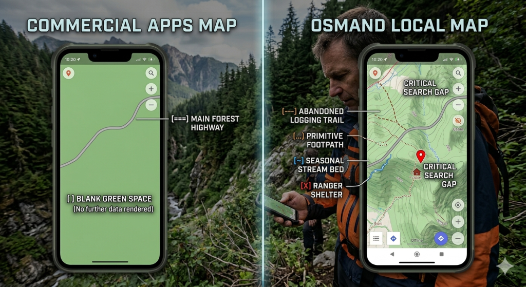
The fundamental constraint of any wilderness rescue operation is the lack of cellular coverage. Standard mobile maps download geographic tiles in real time based on the user’s location. When a network signal drops to zero, these applications display blank screens or low-resolution cached imagery that lacks operational utility.
Standalone Local Vector Databases
OsmAnd resolves this dependency by operating entirely via local vector map files (.obf format) stored directly on the device’s internal flash memory or secure digital (SD) card. Vector data isolates geographical data into distinct mathematical layers (points, lines, and polygons) rather than flat static images.
A single file covering an entire state or province occupies only a few hundred megabytes, yet it contains the precise coordinates of every single geographic asset within that region. Because the rendering engine is fully local, zooming in, rotating the map, and recalculating routes require zero network data.
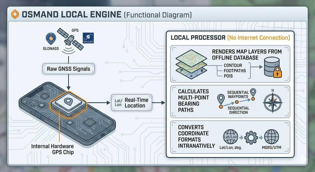
Discrete Hardware GNSS Processing
To determine the location of a field rescue team, OsmAnd bypasses cellular tower triangulation entirely. It communicates directly with internal Global Navigation Satellite System (GNSS) hardware chips. This allows the host device to process signals from multiple orbital satellite constellations simultaneously, including:
- GPS (United States)
- GLONASS (Russia)
- GALILEO (European Union)
- BeiDou (China)
By parsing raw time-of-flight data from these satellite arrays, the device establishes positioning lock within meters, even when the phone is placed in airplane mode with the SIM card removed. This absolute detachment from local telecom grids ensures that field assets remain trackable and oriented in the deepest wilderness zones.
2. Granular Spatial Data: Crowdsourced Micro-Features via OpenStreetMap
The effectiveness of a search strategy depends heavily on the accuracy of the baseline map. Commercial map databases are engineered for vehicular navigation, urban route optimization, and corporate point-of-interest discoverability. They systematically filter out minor geographical elements to save bandwidth and keep interfaces clean for everyday commuters. For a search team looking for an injured person, those hidden details are exactly what they need.
The OpenStreetMap (OSM) Framework
OsmAnd draws its data directly from the OpenStreetMap project, a global, open-source collaborative geographic database. Because any trained user can contribute data, local outdoor enthusiasts, park rangers, and professional surveyors constantly update OSM with micro-level terrain features.
When a rescue team downloads an OsmAnd offline vector package, they gain access to a dense network of minor topographical assets that are completely absent from standard consumer applications.
Tactical Application of Unlisted Assets
During a missing person investigation, historical tracking data shows that lost individuals frequently follow the path of least resistance when fatigued, or they seek natural resources to survive. OsmAnd renders specific data tags that are critical in these scenarios:
highway=pathorhighway=track: Indicates primitive footpaths, game trails, or abandoned logging roads where a missing hiker may have strayed from the main tourist trail.waterway=streamornatural=water: Identifies minor water channels, seasonal streams, and drainage basins. Fatigued individuals often head downhill toward water sources, making these high-probability search targets.amenity=shelterortourism=alpine_hut: pinpoints remote backcountry shelters, hunter lean-tos, and abandoned structures where a lost person might seek refuge from harsh weather.man_made=water_wellornatural=spring: Identifies localized fresh water access points in arid or dense jungle terrain.
By exposing these specific assets on the field screen, search coordinators can build tactical hypotheses regarding the subject’s movement patterns, directing search teams to specific points instead of executing blind sweeps through trackless wilderness.
3. Topographic Analysis: Offline Elevation Layers and Slope Mechanics
Flat maps hide the physical barriers that dictate the speed, safety, and direction of a search operation. A straight line drawn on a basic map might look like a short fifteen-minute walk, but if that line crosses a cliff face or a steep ravine, the route becomes impossible or highly dangerous. OsmAnd addresses this limitation by embedding dedicated topographic analysis tools that operate entirely offline.
Contour Line Integration
By activating the Topographic Features plugin, searchers overlay precise contour lines onto the vector base map. These lines utilize Digital Elevation Model (DEM) data sourced from international satellite radar missions, such as the Shuttle Radar Topography Mission (SRTM).
Contour lines join points of equal elevation above sea level. When lines are spaced tightly together, it indicates a rapid change in altitude over a short horizontal distance, alerting the team to a cliff, bluff, or steep drop-off. Wide spacing indicates flat or gently sloping terrain.
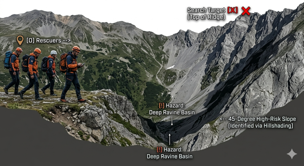
Hillshading and Slope Slope Visualization
Reading raw contour lines requires training and cognitive effort, which can be difficult under high-stress field conditions. OsmAnd simplifies this by rendering local hillshading and slope maps.
- Hillshading applies artificial shadows to the map based on simulated sunlight, highlighting ridges, valleys, and depressions in clear 3D depth.
- Slope Maps color-code the terrain based on steepness angles. For example, slopes between 0 and 15 degrees appear clear, while slopes exceeding 30 degrees can be highlighted in dark orange or red.
This visualization provides immediate tactical value:
- Risk Mitigation for Rescuers: Team leaders can see upcoming vertical hazards long before reaching them, preventing the team from walking into dangerous blind drops at night or in thick fog.
- Predictive Behavior Modeling: In lost-person statistics, specific profiles (such as children or elderly individuals with cognitive impairments) rarely climb steep slopes voluntarily; they almost always wander downward into natural drainage channels. Slope maps allow commanders to instantly identify these paths of least resistance.
- Physical Speed Calculations: If a rescue team must reach a specific point, the team leader can use the slope data to calculate travel times accurately, factoring in how steep climbs slow down personnel.
4. Operational Interoperability: Multi-Format Coordinate Translation
A major breakdown point during multi-agency emergency operations is communication mismatch. A typical search can involve civilian volunteers, state police units, military personnel, and national air rescue assets. Each entity often uses entirely different coordinate and spatial grid formats to report locations.
Native Grid System Compatibility
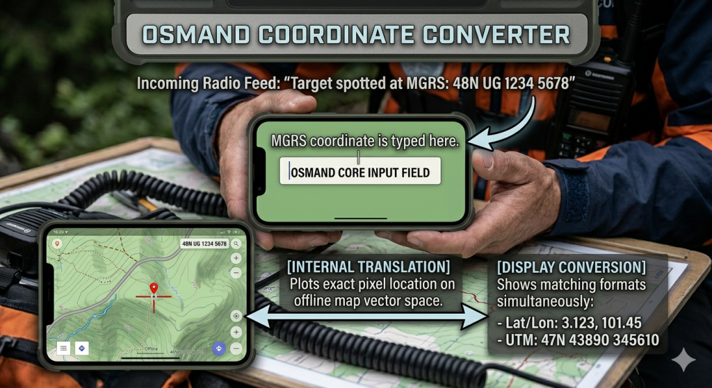
If a helicopter pilot radios down the location of a spotted piece of clothing using military coordinates, a ground team using a basic consumer phone app cannot use that data directly. They would have to stop, open a separate translation app (which usually requires internet access), convert the numbers, and copy them back into their map.
OsmAnd solves this by embedding an internal, offline multi-format coordinate search and display engine. Rescuers can change the application’s primary spatial readout system via internal settings. Supported coordinate systems include:
- Latitude/Longitude: Available in Decimal Degrees (
DD.ddddd), Degrees/Decimal Minutes (DD°MM.mmm'), and Degrees/Minutes/Seconds (DD°MM'SS.s"). - UTM (Universal Transverse Mercator): Divides the earth into sixty distinct vertical zones, widely used by wilderness first responders and land surveyors.
- MGRS (Military Grid Reference System): The standard geocoordinate system used across NATO armed forces and national defense agencies for high-precision grid targeting.
- OLC (Open Location Code / Plus Codes): A grid system that compresses coordinates into short alphanumeric strings, ideal for clear verbal transmission over noisy radio channels.
Real-Time Cross-Verification
When an operator inputs any approved coordinate string into OsmAnd’s offline search interface, the internal processor handles the geometric math locally. It places a precise waypoint on the map instantly.
Furthermore, when the operator selects that waypoint, the app can display the location in all major formats simultaneously on the screen. The ground team can read the decimal coordinates to a civil ambulance crew, read the MGRS string to a military helicopter, and look at the visual map trail themselves, ensuring seamless integration across all agencies involved.
5. Empirical Accountability: GPX Tracking and Sector Clearance Verification
In modern rescue management, a search sector is never considered “cleared” simply because a team walked through it. Search managers require verifiable data proving that the team covered the grid lines close enough to find the missing subject. This tracking process must be automated, high-precision, and tamper-proof.
The Trip Recording Plugin
OsmAnd includes a professional data logging utility called the Trip Recording Plugin. When activated, this tool runs as a background service, pulling location updates directly from the satellite chip at user-defined intervals (ranging from once every 30 seconds down to a continuous 1-second capture rate).
The application outputs standard, uncompressed XML data formatted as a .gpx (GPS Exchange Format) file. This file records an unbroken timeline of the team’s path, where each point contains:
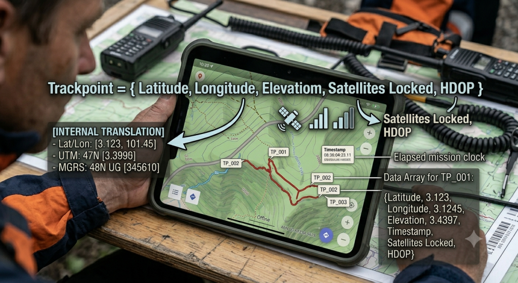
HDOP (Horizontal Dilution of Precision) serves as an integrated quality metric, documenting the exact accuracy of the satellite lock at that moment.
Mathematical Quality Assurance at Base Camp
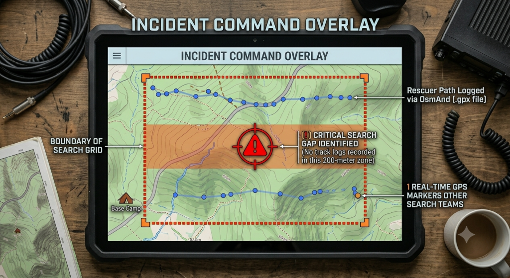
When a search team completes its operational shift and returns to the Incident Command Post (ICP), they do not rely on memory to report their progress. They export the recorded .gpx file from OsmAnd. Because there is no cell service, this file is transferred to the command laptop using a local physical connection, micro-SD card swap, or a direct Bluetooth peer-to-peer transfer.
The search commander imports these files directly into a central mapping computer running professional software like QGIS, CalTopo, or SARTopo. This combines the real-world movements of every single deployment team into a single, comprehensive view:
- Locating Coverage Gaps: The commander can analyze the space between the parallel paths walked by the teams. If the spacing between team tracks exceeds the visual range possible in thick brush (e.g., a 200-meter gap in visibility under 15 meters), the system flags that gap as an unsearched blind spot.
- Tracking Speed and Fatigue: The timestamps embedded within the
.gpxfile reveal how fast the team moved through different areas. A sudden drop in speed can pinpoint difficult terrain features like dense briars or swampy ground, helping managers optimize speed estimates for the next team deployment. - Legal and Operational Documentation: The collected files serve as permanent, legal proof of the operation’s thoroughness. If a search must be audited or reviewed later, the tracking records prove exactly where, when, and how comprehensively the field teams searched the wilderness.
Technical Performance Breakdown
| Operational Category | Commercial Applications (Waze / Google Maps) | OsmAnd System Integration |
| Data Source Dependency | Remote servers; fails immediately without internet connectivity. | Completely local databases stored on the device’s internal storage. |
| Canopy Penetration | Low; relies heavily on assisted cell tower triangulation (A-GPS). | High; pulls directly from multiple satellite arrays (GPS, GLONASS, Galileo). |
| Backcountry Path Detail | Stripped out; prioritizes urban streets and commercial businesses. | Complete OSM data; maps footpaths, streams, and wilderness structures. |
| Coordinate System Support | Limited to standard decimal latitude and longitude formatting. | Native processing of UTM, MGRS, and Open Location Plus Codes. |
| Path Data Logging | Hidden/Proprietary; tracked for personal account histories only. | Local export of raw .gpx file arrays with integrated precision data. |
| Elevation Visibility | Flat 2D rendering; lacks localized topography profiles. | Local rendering of contour lines, hillshading layers, and slope steepness. |
Conclusion
OsmAnd bridges the gap between specialized, expensive handheld GPS equipment and consumer smartphones. In search and rescue operations, its open-source design allows teams to deploy an advanced mapping system to every single field member without hardware budget constraints. By removing dependencies on cell towers, providing detailed terrain features, supporting professional coordinate grids, and generating clear tracking logs, the application functions as a reliable, rugged tool that keeps rescue teams safe and helps them find missing individuals faster.


2 comments