ScoutCAT: The Free Offline POTA, SOTA, and WWFF Activation Planning Map for Mobile
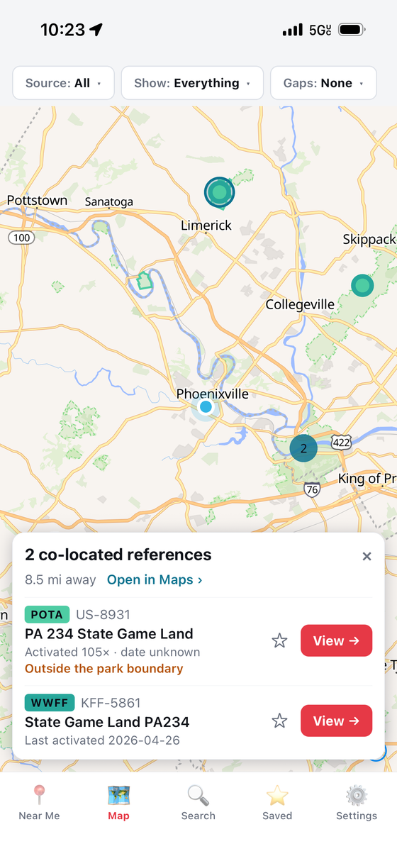
TL;DR: ScoutCAT by Casey Stanton (K3SBP) is a free, offline-first mobile application for iOS and Android that consolidates over 383,000 POTA, SOTA, WWFF, WWBOTA, and LLOTA references onto a single map. Featuring real park boundary polygon rendering, gap hunting filters (finding over 221,000 never-activated references or unworked band/mode combinations), co-located multi-program detection, and zero-signal offline capability, it transforms how portable operators scout and plan field deployments.
Every portable operator knows the frustration of arriving at a remote trail or mountain pass only to watch their mobile phone display “No Service.” You pull up a browser to verify your park reference number or check whether your operating table sits inside the legal state forest boundary, but the web page refuses to load. The online spotting maps, interactive databases, and elevation profiles vanish the moment you step outside cellular range.
While general backcountry mapping apps like Gaia GPS or OnX provide offline topographic layers, they know nothing about amateur radio award programs. They don’t know what constitutes a valid Parks on the Air (POTA) entity, which summits qualify for Summits on the Air (SOTA) points, or whether a nearby nature preserve also counts as a World Wide Flora and Fauna (WWFF) reference.
Developed by Casey Stanton (K3SBP) under the Aspen Ventures umbrella, ScoutCAT solves this problem cleanly. Part of the popular -CAT software suite (which includes POTACAT and ECHOCAT), ScoutCAT puts over 383,000 worldwide radio references into your pocket with 100% offline capability. It introduces sophisticated “gap hunting” filters that reveal never-activated parks and unworked band/mode combinations, draws true boundary polygons, and operates entirely in airplane mode with zero subscriptions, zero accounts, and zero tracking.
Last updated: August 2026.
What Is ScoutCAT?
ScoutCAT is an offline-first mobile application for amateur radio operators that aggregates over 380,000 portable references across five major award programs to enable activation scouting, gap hunting, and park boundary verification without cellular connectivity.
+-------------------------------------------------------------------------+
|                        ScoutCAT SYSTEM TOPOLOGY                         |
+-------------------------------------------------------------------------+
|                                                                         |
|  [ Five Major Award Databases (Nightly Sync via Wi-Fi) ]                |
|  +--------------+-------------+-------------+-------------+----------+  |
|  | POTA (Parks) | SOTA (Peaks)| WWFF (Flora)|WWBOTA(Bunkr)|LLOTA(Lake|  |
|  +--------------+-------------+-------------+-------------+----------+  |
|         |              |             |             |           |        |
|         +--------------+-------------+-------------+-----------+        |
|                                      |                                  |
|                                      v                                  |
|                  +---------------------------------------+              |
|                  | Local Offline SQLite Spatial Database |              |
|                  | (Stored Directly on iOS / Android)    |              |
|                  +---------------------------------------+              |
|                                      |                                  |
|         +----------------------------+----------------------------+     |
|         |                            |                            |     |
|         v                            v                            v     |
|  +--------------------+    +--------------------+    +---------------+  |
|  | 100% Offline Map   |    | Gap Hunting Engine |    | Boundary Poly |  |
|  | - Vector Tile Mesh |    | - Never Activated  |    | - Spatial In- |  |
|  | - Offline Search   |    | - 1+ Year Dormant  |    |   Out Verdict |  |
|  | - Distance/Bearing |    | - Band/Mode Firsts |    | - Co-Location |  |
|  +--------------------+    +--------------------+    +---------------+  |
|         |                            |                            |     |
|         +----------------------------+----------------------------+     |
|                                      |                                  |
|                                      v                                  |
|  [ Zero-Signal Field Operating: Airplane Mode / SOTA Peak / POTA Trail ]|
|                                                                         |
+-------------------------------------------------------------------------+
Unlike traditional web directories that require constant client-server round-trips, ScoutCAT downloads full reference datasets and spatial vector layers directly to your device storage over Wi-Fi before you leave the shack. Once downloaded, all core features – including interactive map rendering, multi-criteria filtering, distance calculations, bearing indicators, and complete activation logs – operate with zero cellular reception.
Five Award Programs on a Single Offline Map
One of the greatest operational hurdles in portable operating is managing multiple disparate programs. An operator hunting for a weekend deployment traditionally had to juggle five different websites, each with its own search syntax, mapping interface, and reference format.
+-------------------------------------------------------------------------+
|                      SUPPORTED PORTABLE PROGRAMS                        |
+-------------------------------------------------------------------------+
|                                                                         |
| Program    Full Name                    Scope       Primary Focus       |
| ----------------------------------------------------------------------- |
| POTA       Parks on the Air             Global      Parks & Reserves    |
| SOTA       Summits on the Air           Global      Mountain Summits    |
| WWFF       World Wide Flora and Fauna   Global      Protected Ecology   |
| WWBOTA     Worldwide Bunkers on the Air Global      Historic Bunkers    |
| LLOTA      Lagos y Lagunas on the Air   Global      Lakes & Lagoons     |
|                                                                         |
| Total Worldwide Database: Over 383,989 Verified Radio References        |
|                                                                         |
+-------------------------------------------------------------------------+
ScoutCAT unifies these programs into a single searchable interface:
- Parks on the Air (POTA): Covers national parks, state forests, wildlife management areas, recreation reserves, and provincial conservation lands worldwide.
- Summits on the Air (SOTA): Covers accredited mountain peaks meeting the prominence and elevation thresholds defined by national SOTA associations.
- World Wide Flora and Fauna (WWFF): Global conservation network focusing on biosphere reserves, Ramsar wetland sites, and biodiversity habitats.
- Worldwide Bunkers on the Air (WWBOTA): Historical fortifications, civil defence shelters, radar installations, and military bunker references.
- Lagos y Lagunas on the Air (LLOTA): Natural and artificial lakes, lagoons, reservoirs, and inland water bodies.
Instead of opening five apps or bookmarking multiple web pages, a single query in ScoutCAT reveals every qualifying entity surrounding your current location or planned route.
The Art of Gap Hunting: Finding Never-Activated References
In the world of portable amateur radio, activating a well-trodden park is enjoyable. But putting a rare or untouched reference on the air for the very first time offers unmatched excitement.
Across the globe, more than 221,000 references have never been activated by any amateur radio operator. ScoutCAT introduces specialized “gap filters” specifically engineered to find these elusive opportunities:
+-------------------------------------------------------------------------+
|                          GAP FILTER WORKFLOW                            |
+-------------------------------------------------------------------------+
|                                                                         |
|  [ Entire Database: 383,989 References ]                                |
|         |                                                               |
|         +---> [ Filter: "Never Activated" ] ------------------------+   |
|         |     (Isolates 221,000+ untouched entities)                |   |
|         |                                                           v   |
|         +---> [ Filter: "Not in Last Year" ] ---------------> [ TARGET  |
|         |     (Identifies forgotten / dormant locations)      |  LIST ] |
|         |                                                           ^   |
|         +---> [ Filter: "Band & Mode Firsts" ] -------------+   |
|               (No CW, No Phone, No Data, No 80m/40m/20m)            |   |
|                                                                         |
+-------------------------------------------------------------------------+
1. “Never Activated” Filter
This filter instantly removes all references that have previously been put on the air, highlighting only virgin entities. For activators aiming to earn program-first certificates or grant rare “all-time new one” (ATNO) contacts to hunters, this single toggle replaces hours of manual cross-referencing.
2. “Not in the Last Year” Filter
Many parks or summits were activated once five years ago and subsequently forgotten. This filter isolates dormant locations that are due for a fresh activation, making them prime targets for local weekend excursions.
3. Band and Mode Firsts
Even if a park has thousands of logged contacts on 20m SSB, it may never have been activated on CW, FT8, 80m, or 10m. ScoutCAT inspects the historical band and mode matrix of each reference, allowing CW and digital enthusiasts to claim distinct mode firsts on established ground.
Real Park Boundary Polygons and In-Boundary Geofencing
A common failure mode of basic mapping tools is representing a park as a single static coordinate pin placed in the geographic center. National forests and state parks span complex, irregular boundaries that stretch across dozens of square kilometers.
+-------------------------------------------------------------------------+
|                     BOUNDARY & CO-LOCATION ANALYSIS                     |
+-------------------------------------------------------------------------+
|                                                                         |
|    +-------------------------------------------------------------+      |
|    | POTA Boundary Polygon (e.g. State Forest / Reserve)         |      |
|    |                                                             |      |
|    |      +-----------------------------------------------+      |      |
|    |      | WWFF Wetland Ecological Reserve (Shared Ground)|      |      |
|    |      |                                               |      |      |
|    |      |   [*] Operator GPS Location:                  |      |      |
|    |      |       - Verdict: INSIDE POTA (K-1234)         |      |      |
|    |      |       - Verdict: INSIDE WWFF (KFF-0567)       |      |      |
|    |      |       -> QUALIFIES FOR DUAL "TWO-FER" QSO!    |      |      |
|    |      |                                               |      |      |
|    |      +-----------------------------------------------+      |      |
|    |                                                             |      |
|    +-------------------------------------------------------------+      |
|                                                                         |
+-------------------------------------------------------------------------+
True Polygon Boundaries
ScoutCAT draws full vector polygon outlines of park borders directly onto the offline map. When you hike into a recreation area, the app performs a real-time point-in-polygon spatial calculation against your device GPS, displaying an immediate status verdict: INSIDE or OUTSIDE the boundary.
(Note: Boundary polygons in ScoutCAT are calculated against public geospatial datasets as a navigation convenience. Activators must always respect posted property signage, land management rules, and local legal access rights).
Co-Located “Two-Fer” and Multi-Program Grouping
When a SOTA summit sits inside a POTA state park, or a WWFF nature reserve overlaps with a lake, ScoutCAT automatically groups the co-located references. Activators can see at a glance that a single operating position qualifies for two or three distinct program credits simultaneously, maximising the value of every contact for hunters worldwide.
100% Offline Architecture: Zero Signal, Zero Tracking
Mobile applications designed for outdoor navigation frequently fail due to invasive cloud dependencies, mandatory user logins, and heavy background tracking frameworks. ScoutCAT was designed from the ground up to respect both operator battery life and privacy.
+-------------------------------------------------------------------------+
|                   OFFLINE STORAGE & PRIVACY CONTROLS                    |
+-------------------------------------------------------------------------+
|                                                                         |
|  [ Wi-Fi Ingest ] -> Download State / Country / Global Regional Packs   |
|                                                                         |
|  Device Storage:                                                        |
|  - Highly compressed vector tiles and spatial indices                   |
|  - Instant offline text search and fuzzy reference matcher              |
|  - Hardware GPS bearing and real-time distance calculations             |
|                                                                         |
|  Privacy & Security Guarantee:                                          |
|  - 100% Free with No Ads and No In-App Subscriptions                   |
|  - Zero Account Registration Required                                   |
|  - Zero Telemetry / Analytics / Location Tracking                       |
|  - GPS coordinates remain strictly on-device                            |
|                                                                         |
+-------------------------------------------------------------------------+
Modular Regional Downloads
To prevent mobile storage bloat, ScoutCAT lets users download exactly the regions they need:
- Local State / Province: Lightweight download taking just a few megabytes.
- National / Continental: Broader package for regional road trips.
- Entire World: Complete global dataset covering all 383,989 references and boundary polygons for international DXpeditions.
Absolute Privacy
ScoutCAT requires no email address, no password, and no account creation. It transmits no telemetry back to external servers, and your physical GPS location never leaves your phone hardware.
The Complete -CAT Family Ecosystem
ScoutCAT isn’t an isolated tool; it represents the field reconnaissance pillar of Casey Stanton (K3SBP)’s broader -CAT amateur radio software ecosystem:
+-------------------------------------------------------------------------+
|                           THE -CAT ECOSYSTEM                            |
+-------------------------------------------------------------------------+
|                                                                         |
|  1. ScoutCAT (iOS & Android)                                            |
|     - Offline activation planning, gap hunting, and boundary map.       |
|                                                                         |
|  2. POTACAT (Desktop: Windows, macOS, Linux)                            |
|     - Free, open-source live spot aggregator with one-click CAT QSY.    |
|     - Integrates with Hamlib and FlexRadio for instant rig tuning.      |
|                                                                         |
|  3. ECHOCAT (Mobile: iOS & Android)                                     |
|     - Remote station client for phone-based SSB, CW paddles, FT8, SSTV. |
|                                                                         |
|  4. MorseCAT                                                            |
|     - Modern Morse code and CW training environment.                    |
|                                                                         |
+-------------------------------------------------------------------------+
Together, these applications form a cohesive workflow: an operator scouts untouched entities on ScoutCAT, hunts active callers from the home shack on POTACAT, controls their base station from the trail via ECHOCAT, and polishes their high-speed CW skills using MorseCAT.
Comparison: ScoutCAT vs Other Field Mapping & Spotting Tools
To understand where ScoutCAT fits into a portable operator’s toolkit, consider how it compares to alternative web and mobile tools:
| Feature | ScoutCAT (K3SBP) | Official POTA.app | SOTAwatch / SOTAmaps | Gaia GPS / OnX | HamAlert |
|---|---|---|---|---|---|
| Primary Focus | Offline Field Planning | Web Spotting & Logs | SOTA Planning & Spots | Backcountry Trails | Spot Notifications |
| Offline Map Operation | 100% Offline (On-Device) | Online Only (Browser) | Online (Partial Cache) | 100% Offline | Online Only (Push) |
| Programs Supported | POTA, SOTA, WWFF, Bunkers, Lakes | POTA Only | SOTA Only | General Trails | DX, POTA, SOTA |
| Total References | 383,989+ Worldwide | ~45,000+ POTA | ~140,000+ Summits | Non-Ham Data | Spot Ingest Only |
| Gap Hunting Filters | Yes (Never Activated / Firsts) | Limited (Recent only) | No | No | Trigger Based |
| Park Boundary Polygons | Yes (Vector Polygons) | Yes (Web Only) | SOTA Prominence Rings | Public Land Layers | No |
| Co-Location Grouping | Yes (Multi-Program) | No | No | No | No |
| Account Required | None (Zero Login) | Free Account | Free Account | Paid Subscription | Free Account |
| Price | 100% Free / No Ads | 100% Free | 100% Free | $40 – $100 / Year | Free / Donation |
Step-by-Step Guide: Planning Your Next Field Activation with ScoutCAT
Follow this practical workflow to plan a successful, high-value field activation:
+-------------------------------------------------------------------------+
|                      ACTIVATION PLANNING WORKFLOW                       |
+-------------------------------------------------------------------------+
|                                                                         |
| Step 1: Install ScoutCAT from Google Play or Apple App Store            |
| Step 2: Download Your Local State or National Offline Database          |
| Step 3: Enable "Never Activated" or "Band/Mode Firsts" Gap Filters      |
| Step 4: Inspect Surrounding Targets for Co-Located References           |
| Step 5: Hike to the Site, Verify Polygon Boundaries, and Get On the Air!|
|                                                                         |
+-------------------------------------------------------------------------+
Step 1: Install and Initialize
Download ScoutCAT on Android via the Google Play Store (search com.potacat.scoutcat) or on iOS via the Apple App Store.
Step 2: Download Offline Datasets Over Wi-Fi
Open the app settings while connected to your home Wi-Fi network. Select your region or state to download the local spatial indices and vector boundary maps. Once downloaded, test the app by enabling Airplane Mode to ensure offline rendering is active.
Step 3: Configure Your Scouting Strategy
Navigate to the Near Me or Map tab:
- If you want to put an untouched park on the air, enable the Never activated filter.
- If you’re operating exclusively CW or QRP digital, enable the Band & Mode Firsts filter to pinpoint entities lacking CW or FT8 records.
Step 4: Identify Co-Located Opportunities
Review candidate locations on the map. Look for markers displaying multi-program badges (such as a POTA park overlapping with a WWFF ecological reserve). Note all reference numbers in your field notepad.
Step 5: Verify Boundaries on the Trail
Upon arrival at the site, open ScoutCAT and observe your live GPS location relative to the drawn park boundary polygon. Confirm that your operating table, antenna wire, and power source sit securely inside the reference perimeter before calling CQ.
Frequently Asked Questions (FAQ)
What is ScoutCAT?
ScoutCAT is a free, offline-first mobile app for iOS and Android by Casey Stanton (K3SBP) that maps over 383,000 POTA, SOTA, WWFF, WWBOTA, and LLOTA references with full boundary polygons and gap hunting filters.
Does ScoutCAT require internet or cell service?
No. Once you download your chosen regional reference database over Wi-Fi, ScoutCAT runs 100% offline, including all maps, search queries, distance calculations, boundary checks, and historical activation records.
How do I find parks that have never been activated?
Open the filters menu in ScoutCAT and toggle the “Never activated” switch. The map and list will immediately filter to show only virgin references that have never been put on the air.
Can ScoutCAT log my contacts or control my transceiver?
No. ScoutCAT is strictly an activation planning and reference mapping tool. For live spotting and CAT radio control, use POTACAT on desktop, or ECHOCAT for mobile remote station control.
Is ScoutCAT completely free?
Yes. ScoutCAT is 100% free with no subscription fees, no in-app purchases, no advertisements, no required user account registration, and zero location tracking.
Why ScoutCAT Is an Indispensable Tool for Portable Radio Operators
Portable amateur radio has seen explosive growth over the last five years, driven by the accessibility of POTA, SOTA, and lightweight QRP transceivers. Yet, the software supporting these field operations often lagged behind, trapped in browser-bound web portals that broke the moment cellular coverage disappeared.
ScoutCAT fundamentally modernizes activation planning. By uniting five global award programs, compiling over 383,000 references into a sub-second offline database, rendering real boundary polygons, and empowering operators to hunt virgin activations through intuitive gap filters, Casey Stanton (K3SBP) has delivered a masterpiece of amateur radio utility.
Whether you’re planning a weekend mountain summit activation, seeking out your first unactivated state forest, or double-dipping on co-located flora and fauna reserves, ScoutCAT belongs on every portable operator’s phone.
73 from 9M2PJU.
Sources and Further Reading
- ScoutCAT Official Website – Official homepage, feature breakdowns, and app store links.
- POTACAT Main Project Hub – Central portal for the -CAT amateur radio software family by Casey Stanton (K3SBP).
- Parks on the Air (POTA) Official Portal – Rules, park directory, activator guidelines, and hunter leaderboards.
- Summits on the Air (SOTA) Association – Official summit database, association manuals, and scoring criteria.
- World Wide Flora and Fauna (WWFF) – Global amateur radio environmental conservation program rules and reference lists.
- Worldwide Bunkers on the Air (WWBOTA) – Historical fortification and military bunker activation directory.
- HamRadio.my Amateur Radio Resources – Technical articles, open-source projects, and field operating guides for amateur radio enthusiasts.


Post Comment